Jämshög 1:1, Grave marked by stone/block in Olofström Municipality, Blekinge, Sweden
Location: Olofström Municipality
GPS coordinates: 56.20161,14.60067
Latest update: November 11, 2025 19:37
Drögsperyd
4.1 km
Djupadal
2.5 km
Skinsagylet Nature Reserve
1.7 km
Enen i Möllekulla
3.3 km
En ormtall
3.6 km
Gränums bränneri
2.3 km
Jämshög 66:1
4.5 km
Jämshög 64:1
3.8 km
Jämshög 547
4.3 km
Jämshög 67:1
4.5 km
Gammalstorp 77:1
3.2 km
Jämshög 62:1
3.7 km
Jämshög 58:1
3.9 km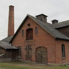
Distillery Gränum
2.3 km
Näsum 16:2
4.9 km
Jämshög 190
3.9 km
Jämshög 191
3.8 km
Jämshög 333
4.3 km
Jämshög 425
4.8 km
Näsum 189
3.4 km
Jämshög 550
4.4 km
Jämshög 576
2.9 km
Jämshög 58:2
3.9 km
Gammalstorp 77:2
3.3 km
Gammalstorp 77:3
3.3 km
Näsum 16:1
5 km
Näsum 241
2.6 km
Boa Olofströms Golfklubb
800 mReviews
Visited this place? Tap the stars to rate it and share your experience / photos with the community! Try now! You can cancel it anytime.
Discover hidden gems everywhere you go!
From secret cafés to breathtaking viewpoints, skip the crowded tourist spots and find places that match your style. Our app makes it easy with voice search, smart filtering, route optimization, and insider tips from travelers worldwide. Download now for the complete mobile experience.

A unique approach to discovering new places❞
— Le Figaro
All the places worth exploring❞
— France Info
A tailor-made excursion in just a few clicks❞
— 20 Minutes