Rogsta 19:1, röse i Hälsingland
Location: Hudiksvall Municipality
GPS coordinates: 61.85957,17.27123
Latest update: November 22, 2025 08:38

Rogsta 188:1
2.2 km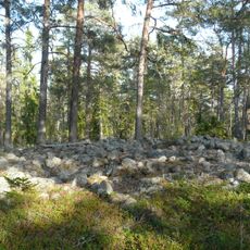
Harmånger 77:1
2.6 km
Rogsta 174:1
2.3 km
Rogsta 20:3
171 m
Rogsta 196:1
2.9 km
Rogsta 20:2
163 m
Rogsta 19:4
57 m
Rogsta 170:1
2.1 km
Rogsta 19:2
31 m
Harmånger 288
4.3 km
Harmånger 58:1
587 m
Harmånger 82:1
3.4 km
Harmånger 48:1
3.1 km
Konungshuset
3.4 km
Harmånger 33:3
4.4 km
Rogsta 19:3
46 m
Harmånger 143:1
2.2 km
Harmånger 57:2
534 m
Harmånger 57:1
538 m
Harmånger 71:1
3.2 km
Harmånger 70:1
3.2 km
Rogsta 20:1
157 m
Harmånger 33:1
4.4 km
Rogsta 178:1
825 m
Rogsta 21:1
339 m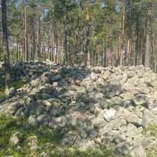
Högarna
4.2 km
Rogsta 52:1
4.4 km
Hästasand
3.5 kmReviews
Visited this place? Tap the stars to rate it and share your experience / photos with the community! Try now! You can cancel it anytime.
Discover hidden gems everywhere you go!
From secret cafés to breathtaking viewpoints, skip the crowded tourist spots and find places that match your style. Our app makes it easy with voice search, smart filtering, route optimization, and insider tips from travelers worldwide. Download now for the complete mobile experience.

A unique approach to discovering new places❞
— Le Figaro
All the places worth exploring❞
— France Info
A tailor-made excursion in just a few clicks❞
— 20 Minutes