Södra Unnaryd 116:1, stone setting in Hylte Municipality, Halland County, Sweden
Location: Hylte Municipality
GPS coordinates: 56.99461,13.54046
Latest update: November 20, 2025 21:27
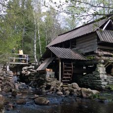
Brunnsbacka sawmill
1.4 km
Ödegärdet
3.2 km
Lunnamossen
3.2 km
Jute stenar
5.2 km
Unnaryds hembygdspark
4.1 km
Södra Unnaryd 103:1
4.2 km
Södra Unnaryd 109:1
705 m
Södra Unnaryd 98:1
3.2 km
2004974 Ett område med blåsippor, Hylteberg 1:5
1.5 km
Södra Unnaryd 445
2.7 km
Mellanberget
565 m
Södra Unnaryd 70:1
4.4 km
Södra Unnaryd 81:1
1.8 km
Mellanberget
552 m
Södra Unnaryd 84:1
3 km
Södra Unnaryd 85:1
3.1 km
Jättebacken
4.7 km
Jälluntofta 21:1
4.4 km
Södra Unnaryd 99:1
3.3 km
Södra Unnaryd 83:1
2.7 km
Södra Unnaryd 68:1
4.7 km
Korpakullen
4.6 km
Jälluntofta 23:1
4.1 km
Södra Unnaryd 86:1
1.6 km
Södra Unnaryd 112:1
434 m
Södra Unnaryd 69:1
4.3 km
Södra Unnaryd 444
858 m
Jälluntofta 21:2
4.4 kmReviews
Visited this place? Tap the stars to rate it and share your experience / photos with the community! Try now! You can cancel it anytime.
Discover hidden gems everywhere you go!
From secret cafés to breathtaking viewpoints, skip the crowded tourist spots and find places that match your style. Our app makes it easy with voice search, smart filtering, route optimization, and insider tips from travelers worldwide. Download now for the complete mobile experience.

A unique approach to discovering new places❞
— Le Figaro
All the places worth exploring❞
— France Info
A tailor-made excursion in just a few clicks❞
— 20 Minutes