Lommaryd 384, röse i Småland
Location: Aneby Municipality
GPS coordinates: 57.93904,14.75117
Latest update: November 24, 2025 01:23
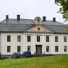
Degla manor
345 m
Degla lövskog
1 km
Vagnsvik 1:6
3.5 km
Lommaryd 36:2
3.1 km
Lommaryd 36:3
3.1 km
Lommaryd 31:1
3.3 km
Frinnaryd 17:2
4.2 km
Lommaryd 270:1
2.3 km
Linderås 48:1
3.5 km
Lommaryd 28:1
1.6 km
Lommaryd 8:1
2.9 km
Lommaryd 4:1
4.1 km
Lommaryd 429
3.8 km
Lommaryd 262:1
3.2 km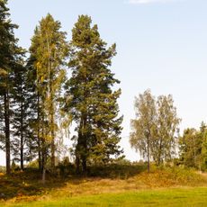
Lommaryd 30:1
3.1 km
Lommaryd 36:1
3.1 km
Lommaryd 262:2
3.3 km
Lommaryd 93:1
2.8 km
Lommaryd 261:1
3.4 km
Lommaryd 271:1
3.2 km
Lommaryd 284:1
1.1 km
Lommaryd 290:1
3.1 km
Lommaryd 269:1
1.8 km
Lommaryd 432
3.2 km
Lommaryd 35:1
3.1 km
Lommaryd 98:1
1.4 km
Linderås 45:1
3.7 km
Linderås 44:1
3.7 kmReviews
Visited this place? Tap the stars to rate it and share your experience / photos with the community! Try now! You can cancel it anytime.
Discover hidden gems everywhere you go!
From secret cafés to breathtaking viewpoints, skip the crowded tourist spots and find places that match your style. Our app makes it easy with voice search, smart filtering, route optimization, and insider tips from travelers worldwide. Download now for the complete mobile experience.

A unique approach to discovering new places❞
— Le Figaro
All the places worth exploring❞
— France Info
A tailor-made excursion in just a few clicks❞
— 20 Minutes