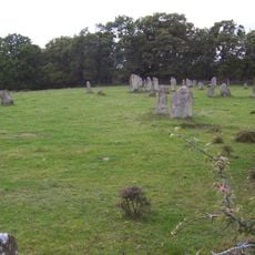
Önnestad 49:1, building in Kristianstad Municipality, Skåne County, Sweden
Location: Kristianstad Municipality
GPS coordinates: 56.06364,13.95588
Latest update: November 24, 2025 02:13
Gräberfeld Stainabjär
4.6 km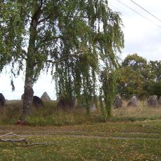
Bröt-Anunds Grab
4.2 km
Åraslövs mosse
2.9 km
Brantaberg-Oreberget
5.1 km
Önnestad 28:1
2 km
Vinslöv 22:2
4 km
Önnestad 7:1
487 m
Bröt-Anunds grav
4.2 km
Sjuplanteboke (numera fyra), St Öllstorps skog
1.4 km
Klövehallar, St Öllstorps skog
1.8 km
Vinslöv 16:1
4.7 km
Vinslöv 131:4
1.2 km
Vinslöv 131:3
1.2 km
Önnestad 44:1
4.5 km
Önnestad 35:1
657 m
Vinslöv 131:1
1.1 km
Ekebacken
4.6 km
Önnestad 47:1
4.7 km
Vinslöv 28:1
4.3 km
Vinslöv 131:2
1.1 km
Ekebacken
4.7 km
Önnestad 42:1
4.4 km
Käringabacken
3.6 km
Önnestad 46:1
4.3 km
Dykarmöllan
1.9 km
Käringabacken
3.6 km
Ekebacken
4.7 km
Käringabacken
3.5 kmReviews
Visited this place? Tap the stars to rate it and share your experience / photos with the community! Try now! You can cancel it anytime.
Discover hidden gems everywhere you go!
From secret cafés to breathtaking viewpoints, skip the crowded tourist spots and find places that match your style. Our app makes it easy with voice search, smart filtering, route optimization, and insider tips from travelers worldwide. Download now for the complete mobile experience.

A unique approach to discovering new places❞
— Le Figaro
All the places worth exploring❞
— France Info
A tailor-made excursion in just a few clicks❞
— 20 Minutes