Finnekumla 57:2, hällristning i Västergötland
Location: Ulricehamn Municipality
GPS coordinates: 57.65143,13.35053
Latest update: November 20, 2025 20:39

Sjöred
1.5 km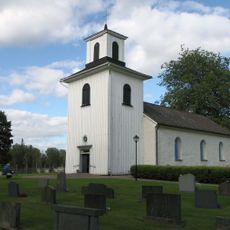
Finnekumla Church
476 m
Finnekumla 13:3
2.5 km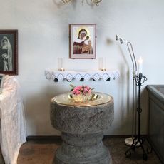
Finnekumla kirkes døpefont
472 m
Finnekumla 13:2
2.5 km
Södra Säms kyrka
2.6 km
Finnekumla 87:2
2.7 km
Finnekumla 13:1
2.5 km
Finnekumla 19:1
1.2 km
Finnekumla 57:1
53 m
Finnekumla 49:1
1 km
Södra Säms kyrka
2.6 km
Grimmesten
1.5 km
Finnekumla 58:1
312 m
Grimmesten
1.5 km
Finnekumla 66:1
301 m
Finnekumla 25:2
1.1 km
Finnekumla 50:1
911 m
Finnekumla 51:1
342 m
1
2.5 km
Finnekumla 25:1
1.1 km
Finnekumla 26:1
228 m
Södra Säm 74:1
2.3 km
Finnekumla 10:1
2.6 km
Finnekumla 21:1
356 m
Finnekumla 95:1
688 m
Finnekumla 96:1
2.1 km
Södra Säms kyrkoruin
2.6 kmReviews
Visited this place? Tap the stars to rate it and share your experience / photos with the community! Try now! You can cancel it anytime.
Discover hidden gems everywhere you go!
From secret cafés to breathtaking viewpoints, skip the crowded tourist spots and find places that match your style. Our app makes it easy with voice search, smart filtering, route optimization, and insider tips from travelers worldwide. Download now for the complete mobile experience.

A unique approach to discovering new places❞
— Le Figaro
All the places worth exploring❞
— France Info
A tailor-made excursion in just a few clicks❞
— 20 Minutes