Herrljunga 61:1, Hügelgrab in Schweden
Location: Herrljunga Municipality
GPS coordinates: 58.07973,13.06054
Latest update: November 24, 2025 02:31

Herrljunga cist
1.3 km
Herrljunga 12:1
1.3 km
Herrljunga 12:2
1.3 km
Hudene 129:1
1.5 km
Herrljunga 53:1
1.5 km
Herrljunga 58:1
443 m
Bäcklingsbackarna
1.5 km
Hudene 111:1
1.4 km
Herrljunga 60:1
337 m
Herrljunga 61:2
12 m
Herrljunga 18:1
504 m
Hudene 91:1
1.5 km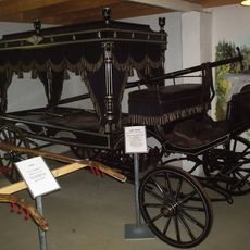
Vagns- och jordbruksmuseum
1 km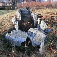
Nya kyrkogården
1.3 km
Hudene 90:1
1.3 km
Herrljunga 10:2
1.3 km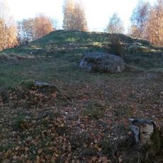
Herrljunga 10:1
1.3 km
Herrljunga 35:1
1.5 km
Hudene 111:2
1.4 km
Herrljunga 57:1
738 m
Aspkullen
1 km
Herrljunga 98:2
1.5 km
Hudene 248:1
1 km
Herrljunga 17:1
673 m
Hudene 245:1
983 m
Herrljunga 30:1
1.4 km
Hudene 107:1
914 m
Hudene 101:3
1.5 kmReviews
Visited this place? Tap the stars to rate it and share your experience / photos with the community! Try now! You can cancel it anytime.
Discover hidden gems everywhere you go!
From secret cafés to breathtaking viewpoints, skip the crowded tourist spots and find places that match your style. Our app makes it easy with voice search, smart filtering, route optimization, and insider tips from travelers worldwide. Download now for the complete mobile experience.

A unique approach to discovering new places❞
— Le Figaro
All the places worth exploring❞
— France Info
A tailor-made excursion in just a few clicks❞
— 20 Minutes