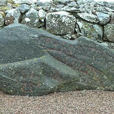
Kölaby 43:1, hällristning i Västergötland
Location: Ulricehamn Municipality
GPS coordinates: 57.99439,13.50310
Latest update: October 26, 2025 15:51
Västergötlands runinskrifter 180
2.5 km
Västergötlands runinskrifter 178
2.4 km
Västergötlands runinskrifter 201
2.1 km
Västergötlands runinskrifter 200
2.1 km
Trädets bibliotek
2.2 km
Kölaby 81:1
995 m
Kölaby 51:1
3.4 km
Kölaby 137:2
2.5 km
Kölaby 137:1
2.5 km
Börstig 75:1
1.4 km
Börstig 70:1
3 km
Kölaby 40:1
3.4 km
Humla 16:1
3.4 km
Börstig 108:1
2.3 km
Börstig 71:1
3 km
Humla 40:1
3.3 km
Kölaby 152:1
3.4 km
Humla 15:4
3.4 km
Börstig 68:1
2 km
Kölaby 107:1
1.5 km
Kölaby 9:1
1.8 km
Kölaby 26:1
1.3 km
Kölaby 104:1
3.4 km
Börstig 107:1
2.7 km
Humla 39:1
3.2 km
Kölaby 60:1
1.6 km
Kölaby 60:2
1.6 km
Börstig 124:1
1.2 kmReviews
Visited this place? Tap the stars to rate it and share your experience / photos with the community! Try now! You can cancel it anytime.
Discover hidden gems everywhere you go!
From secret cafés to breathtaking viewpoints, skip the crowded tourist spots and find places that match your style. Our app makes it easy with voice search, smart filtering, route optimization, and insider tips from travelers worldwide. Download now for the complete mobile experience.

A unique approach to discovering new places❞
— Le Figaro
All the places worth exploring❞
— France Info
A tailor-made excursion in just a few clicks❞
— 20 Minutes