Nittorp 70:1, röse i Västergötland
Location: Tranemo Municipality
GPS coordinates: 57.55711,13.49104
Latest update: June 15, 2024 11:54
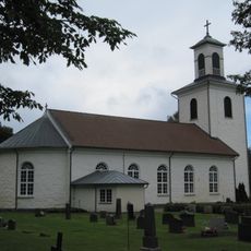
Nittorp Church
835 m
Nittorp 95:1
238 m
Nittorp 49:1
860 m
Nittorp 81:1
698 m
Nittorp 101:1
1.1 km
Nittorp 83:1
797 m
Nittorp 82:3
683 m
Nittorp 135:1
1.1 km
Nittorp 92:2
998 m
Nittorp 92:1
932 m
Nittorp 96:1
553 m
Nittorp 94:1
598 m
Nittorp 97:2
1.1 km
Nittorp 50:3
688 m
Nittorp 82:1
687 m
Nittorp 50:1
699 m
Nittorp 53:1
607 m
Nittorp 69:1
737 m
Nittorp 50:2
671 m
Nittorp 50:4
662 m
Nittorp 82:2
687 m
Nittorp 84:1
902 m
Nittorp 52:2
492 m
Nittorp 52:1
472 m
Nittorp 51:1
390 m
Nittorp 54:1
707 m
Nittorp 97:1
1.1 km
Trollekullen
115 mReviews
Visited this place? Tap the stars to rate it and share your experience / photos with the community! Try now! You can cancel it anytime.
Discover hidden gems everywhere you go!
From secret cafés to breathtaking viewpoints, skip the crowded tourist spots and find places that match your style. Our app makes it easy with voice search, smart filtering, route optimization, and insider tips from travelers worldwide. Download now for the complete mobile experience.

A unique approach to discovering new places❞
— Le Figaro
All the places worth exploring❞
— France Info
A tailor-made excursion in just a few clicks❞
— 20 Minutes