Trollhättan 52:1, stenkammargrav i Västergötland
Location: Trollhättan Municipality
GPS coordinates: 58.26765,12.24413
Latest update: November 15, 2025 03:42
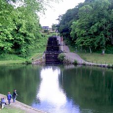
Trollhättan old locks
725 m
Åkerström
764 m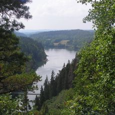
Älvrummet
1.5 km
Ryrbäcken
1.5 km
Trollhättan 149:1
765 m
Trollhättan 160:1
284 m
Trollhättan 50:1
1.5 km
Trollhättan 46:1
1.4 km
Trollhättan 50:2
1.5 km
Trollhättan 53:4
519 m
Trollhättan 161:1
935 m
Trollhättan 170:1
1.4 km
Trollhättan 171:1
1.6 km
Trollhättan 53:2
506 m
Trollhättan 51:1
1.1 km
Trollhättan 153:1
1.3 km
Trollhättan 150:1
674 m
Trollhättan 53:1
518 m
Trollhättan 297
803 m
Trollhättan 148:2
996 m
Trollhättan 49:2
1.5 km
Trollhättan 49:1
1.5 km
Trollhättan 48:1
1.3 km
Trollhättan 148:1
996 m
Trollhättan 144:1
974 m
Arkiv
1 km
Scenic viewpoint
651 m
Scenic viewpoint
758 mReviews
Visited this place? Tap the stars to rate it and share your experience / photos with the community! Try now! You can cancel it anytime.
Discover hidden gems everywhere you go!
From secret cafés to breathtaking viewpoints, skip the crowded tourist spots and find places that match your style. Our app makes it easy with voice search, smart filtering, route optimization, and insider tips from travelers worldwide. Download now for the complete mobile experience.

A unique approach to discovering new places❞
— Le Figaro
All the places worth exploring❞
— France Info
A tailor-made excursion in just a few clicks❞
— 20 Minutes