Otterstad 231:1, spärranordning i Västergötland
Location: Lidköping Municipality
GPS coordinates: 58.66338,13.19369
Latest update: November 22, 2025 17:37
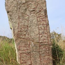
Västergötland Runic Inscription 35
102 m
Skräddartorpet
1.1 km
Otterstad 313
1.5 km
Otterstad 145:1
1.4 km
Otterstad 315
1.5 km
Otterstad 2:1
1.6 km
Otterstad 234:1
1.7 km
Otterstad 36:1
1.8 km
Otterstad 145:2
1.4 km
Otterstad 353
1.2 km
Otterstad 74:1
1.5 km
Otterstad 124:1
1.8 km
Otterstad 30:2
1.3 km
Otterstad 349
932 m
Otterstad 233:1
1.8 km
Otterstad 73:1
1.6 km
Otterstad 188:1
924 m
Otterstad 383
1 km
Otterstad 186:1
990 m
Otterstad 35:1
1.7 km
Otterstad 38:1
1.6 km
Otterstad 186:2
970 m
Otterstad 354
1.2 km
Otterstad 30:1
1.3 km
Otterstad 378
1.3 km
Otterstad 380
920 m
Otterstad 25:1
1.4 km
Otterstad 17:1
1.7 kmReviews
Visited this place? Tap the stars to rate it and share your experience / photos with the community! Try now! You can cancel it anytime.
Discover hidden gems everywhere you go!
From secret cafés to breathtaking viewpoints, skip the crowded tourist spots and find places that match your style. Our app makes it easy with voice search, smart filtering, route optimization, and insider tips from travelers worldwide. Download now for the complete mobile experience.

A unique approach to discovering new places❞
— Le Figaro
All the places worth exploring❞
— France Info
A tailor-made excursion in just a few clicks❞
— 20 Minutes