Öttum 44:1, stone setting in Vara Municipality, Västra Götaland County, Sweden
Location: Vara Municipality
GPS coordinates: 58.30596,13.24098
Latest update: November 24, 2025 02:33
Vinköl
3.3 km
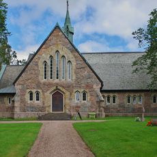
Öttums kyrka
2.1 km
Gubbens sten el Gubbasten
3.4 km
Vinköl 25:2
3.5 km
Norra Vånga 36:3
3 km
Öttum 21:3
1.4 km
Kvänum 4:2
1 km
Kvänum 38:1
2.2 km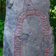
Vg 74 Skolgården (gamla kyrkogården)
3.2 km
Lusthusbacken
3.1 km
Norra Vånga 25:1
2.9 km
Öttum 21:1
1.5 km
Kvänum 3:1
3.5 km
Kvänum 3:2
3.5 km
Kvänum 3:3
3.5 km
Norra Vånga 108:1
3.1 km
Norra Vånga 167:1
3.4 km
Norra Vånga 36:2
3 km
Kvänum 36:1
3.3 km
Vinköl 5:1
3.2 km
Öttum 21:4
1.4 km
Öttum 21:2
1.4 km
Öttum 15:1
1.4 km
Öttum 17:1
583 m
Vinköl 25:1
3.5 km
Norra Vånga 36:1
2.9 km
Norra Vånga 25:2
2.9 km
Kvänum 35:1
3.2 kmReviews
Visited this place? Tap the stars to rate it and share your experience / photos with the community! Try now! You can cancel it anytime.
Discover hidden gems everywhere you go!
From secret cafés to breathtaking viewpoints, skip the crowded tourist spots and find places that match your style. Our app makes it easy with voice search, smart filtering, route optimization, and insider tips from travelers worldwide. Download now for the complete mobile experience.

A unique approach to discovering new places❞
— Le Figaro
All the places worth exploring❞
— France Info
A tailor-made excursion in just a few clicks❞
— 20 Minutes