Romfartuna 241:1, lägenhetsbebyggelse i Västmanland
Location: Västerås Municipality
GPS coordinates: 59.81448,16.52082
Latest update: November 22, 2025 20:53
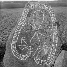
Grällsta Runestone
4.2 km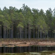
Vinnsjömossen
5.1 km
Kila 42:1
3.2 km
Romfartuna 209:1
2.6 km
Romfartuna 180:1
3.6 km
Kila 40:1
3.1 km
Haraker 75:1
5.4 km
Hallsta by , Romfartuna
5.6 km
Haraker 92:1
4.9 km
Göltorp
4 km
Åkerby skans
3.9 km
Kila 69:1
2.5 km
Haraker 8:1
4.9 km
Kila 50:1
2 km
Kapellbacken
1.7 km
Haraker 92:2
4.9 km
Haraker 94:1
4.2 km
Kumla 8:1
5.8 km
Romfartuna 212:1
2 km
Romfartuna 212:2
2 km
Romfartuna 108:1
5.6 km
Romfartuna 116:1
4.9 km
Romfartuna 115:1
5.2 km
Skalleråsen
5.7 km
Skalleråsen
5.7 km
Romfartuna 147:1
5.8 km
Haraker 6:1
5.4 km
Kila 172:1
3.5 kmReviews
Visited this place? Tap the stars to rate it and share your experience / photos with the community! Try now! You can cancel it anytime.
Discover hidden gems everywhere you go!
From secret cafés to breathtaking viewpoints, skip the crowded tourist spots and find places that match your style. Our app makes it easy with voice search, smart filtering, route optimization, and insider tips from travelers worldwide. Download now for the complete mobile experience.

A unique approach to discovering new places❞
— Le Figaro
All the places worth exploring❞
— France Info
A tailor-made excursion in just a few clicks❞
— 20 Minutes