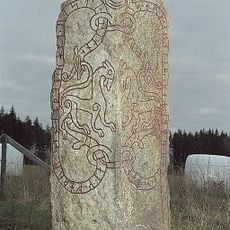
Vårfrukyrka 486:1, hällristning i Uppland
Location: Enköping Municipality
GPS coordinates: 59.69309,17.09278
Latest update: November 24, 2025 02:47
Upplands runinskrifter 770
708 m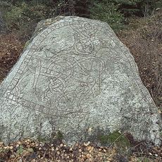
Upplands runinskrifter 771
671 m
Kyrkkullen (el Ål Kyrka)
692 m
Långtora 84:1
666 m
Vårfrukyrka 34:1
1.1 km
Ristingsbro
675 m
Vårfrukyrka 40:1
713 m
Vårfrukyrka 35:1
1.2 km
Långtora 87:3
874 m
Långtora 101:1
588 m
Vårfrukyrka 21:1
730 m
Vårfrukyrka 21:2
721 m
Vårfrukyrka 52:1
968 m
Vårfrukyrka 33:1
1.3 km
Vårfrukyrka 470:1
1.1 km
Långtora 35:1
1.2 km
Vårfrukyrka 273:1
710 m
Borgnäbb
563 m
Vårfrukyrka 39:1
693 m
Långtora 87:2
856 m
Långtora 86:1
831 m
Vårfrukyrka 35:2
1.2 km
Långtora 88:1
839 m
Vårfrukyrka 49:3
899 m
Vårfrukyrka 21:3
717 m
Vårfrukyrka 36:1
1.1 km
Vårfrukyrka 49:2
892 m
Vårfrukyrka 49:1
933 mReviews
Visited this place? Tap the stars to rate it and share your experience / photos with the community! Try now! You can cancel it anytime.
Discover hidden gems everywhere you go!
From secret cafés to breathtaking viewpoints, skip the crowded tourist spots and find places that match your style. Our app makes it easy with voice search, smart filtering, route optimization, and insider tips from travelers worldwide. Download now for the complete mobile experience.

A unique approach to discovering new places❞
— Le Figaro
All the places worth exploring❞
— France Info
A tailor-made excursion in just a few clicks❞
— 20 Minutes