Kjula 16:1, grave field in Södermanland, Sweden
Location: Eskilstuna Municipality
GPS coordinates: 59.40510,16.65803
Latest update: June 15, 2024 09:38
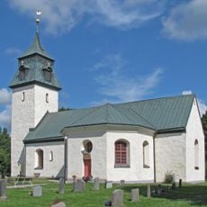
Kjula Church
1.3 km
Sofiebergsåsen
338 m
Hammarby 11:3
1.6 km
Kjula 60:1
1.8 km
Hammarby 11:2
1.6 km
Jäder 67:1
1.6 km
Kjula 18:1
1.5 km
Sö Fv1969;298
1.3 km
Hammarby 11:1
1.7 km
Trafikverkets museer, Väghistoriska samlingarna i Kjula
1.7 km
Kjula 5:1
1.8 km
Jäder 69:2
1.8 km
Jäder 66:1
1.6 km
Kjula 3:2
1.5 km
Kjula 2:1
1.8 km
Kjula 15:1
1.5 km
Kjula 6:1
1.7 km
Jäder 80:1
1.4 km
Kjula 19:2
1.7 km
Kjula 19:1
1.7 km
Kjula 14:1
1.4 km
Jäder 151:1
1.8 km
Jäder 81:1
1.6 km
Jäder 156:1
1.7 km
Kjula 3:1
1.5 km
Jäder 70:1
1.5 km
Jäder 69:1
1.8 km
Kjula 1:1
1.8 kmReviews
Visited this place? Tap the stars to rate it and share your experience / photos with the community! Try now! You can cancel it anytime.
Discover hidden gems everywhere you go!
From secret cafés to breathtaking viewpoints, skip the crowded tourist spots and find places that match your style. Our app makes it easy with voice search, smart filtering, route optimization, and insider tips from travelers worldwide. Download now for the complete mobile experience.

A unique approach to discovering new places❞
— Le Figaro
All the places worth exploring❞
— France Info
A tailor-made excursion in just a few clicks❞
— 20 Minutes