Jo Jonsvallen
Location: Härjedalen Municipality
Inception: 1840
GPS coordinates: 62.09154,14.59879
Latest update: November 6, 2025 02:58
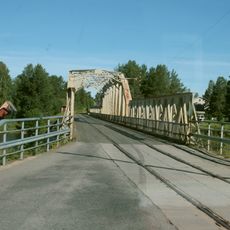
Mankellbron
14.5 km
Duvberg
17.8 km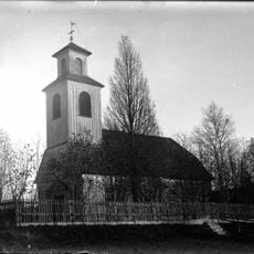
Ängersjö Church
18.4 km
Byarforsen
7.7 km
Tjuvforsen
17.9 km
Getryggen
20.4 km
Högåsen
20.7 km
Fagerbäckens naturreservat
11.5 km
Västansjöbrännan
18.5 km
Haberget
19.6 km
Sandtjärnbergsvallen
20.5 km
Sveg 114:1
19.8 km
Gammelvallen
17.3 km
Bod i Eggen
17.8 km
Torpet Halla
17.2 km
Ängersjö 130:1
17.6 km
Älvros 158:1
13 km
Härbre i Älvros
1.3 km
Härbre i Eggen
17.1 km
Ängersjö 137:1
20.2 km
Tröskloge i Eggen
17.5 km
Älvros 7:1
5.3 km
Byvallen golfbana
10.2 km
Minnessten
18.9 km
Camp Sveg
13.8 km
Björnen
13.8 km
The Smith
19.9 km
Scenic viewpoint
13.4 kmReviews
Visited this place? Tap the stars to rate it and share your experience / photos with the community! Try now! You can cancel it anytime.
Discover hidden gems everywhere you go!
From secret cafés to breathtaking viewpoints, skip the crowded tourist spots and find places that match your style. Our app makes it easy with voice search, smart filtering, route optimization, and insider tips from travelers worldwide. Download now for the complete mobile experience.

A unique approach to discovering new places❞
— Le Figaro
All the places worth exploring❞
— France Info
A tailor-made excursion in just a few clicks❞
— 20 Minutes