Hunnebyn 1:5, naturminne i Melleruds kommun
Location: Mellerud Municipality
Inception: October 21, 1965
GPS coordinates: 58.73141,12.38686
Latest update: June 15, 2024 11:59
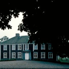
Ekholmens herrgård
883 m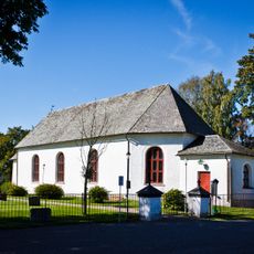
Gunnarsnäs Church
692 m
Årbolsfjället
2.3 km
Sandviken 1:2
2.4 km
Holm 9:1
2.4 km
Gunnarsnäs 31:2
1.7 km
Gunnarsnäs 26:1
1.2 km
Holm 10:3
2.3 km
Holm 101:1
2.5 km
Holm 61:2
2.5 km
Gunnarsnäs 29:1
1.6 km
Bruastenen
812 m
Gunnarsnäs 15:1
2.4 km
Gunnarsnäs 32:2
893 m
Holm 92:1
2.3 km
Holm 59:1
2.2 km
Holm 60:1
2.3 km
Holm 10:2
2.3 km
Holm 10:1
2.3 km
Holm 91:1
2.2 km
Gunnarsnäs 26:2
1.2 km
Holm 61:1
2.5 km
Gunnarsnäs 33:1
1.4 km
Gunnarsnäs 32:1
896 m
Munkaltarekasen
1.3 km
Gunnarsnäs 31:1
1.8 km
Gunnarsnäs 29:3
1.6 km
Gunnarsnäs 29:2
1.6 kmReviews
Visited this place? Tap the stars to rate it and share your experience / photos with the community! Try now! You can cancel it anytime.
Discover hidden gems everywhere you go!
From secret cafés to breathtaking viewpoints, skip the crowded tourist spots and find places that match your style. Our app makes it easy with voice search, smart filtering, route optimization, and insider tips from travelers worldwide. Download now for the complete mobile experience.

A unique approach to discovering new places❞
— Le Figaro
All the places worth exploring❞
— France Info
A tailor-made excursion in just a few clicks❞
— 20 Minutes