En bok sammanväxt med ek, Älmeboda, naturminne i Tingsryds kommun
Location: Tingsryd Municipality
Inception: April 5, 1935
GPS coordinates: 56.59240,15.25261
Latest update: November 23, 2025 04:32
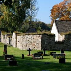
Älmeboda kyrkoruin
303 m
Korrö
4.5 km
Linneryd 135:1
4.4 km
Linneryd 113:1
3.5 km
Älmeboda 135:1
5 km
Kroxmåla Takpannefabrik
4.9 km
Hembygdsgården Rävemåla
4.4 km
Linneryd 107:1
5.2 km
Linneryd 109:1
5.6 km
Älmeboda 216:2
4.8 km
Älmeboda 216:1
4.8 km
Älmeboda 68:1
3.8 km
Linneryd 125:1
3.5 km
Drakarören
5.5 km
Drakaröret
6 km
Linneryd 114:1
3.2 km
Linneryd 116:1
3.6 km
Linneryd 111:1
3.4 km
Linneryd 133:1
4.2 km
Linneryd 110:1
5.5 km
Linneryd 112:1
3.5 km
Lindkullerör
3.9 km
Drakarör
4.1 km
Älmeboda 37:1
4.2 km
Linneryd 108:1
5.6 km
Drakarören
5.5 km
Linneryd 17:1
5.7 km
Pengaröret
3.8 kmReviews
Visited this place? Tap the stars to rate it and share your experience / photos with the community! Try now! You can cancel it anytime.
Discover hidden gems everywhere you go!
From secret cafés to breathtaking viewpoints, skip the crowded tourist spots and find places that match your style. Our app makes it easy with voice search, smart filtering, route optimization, and insider tips from travelers worldwide. Download now for the complete mobile experience.

A unique approach to discovering new places❞
— Le Figaro
All the places worth exploring❞
— France Info
A tailor-made excursion in just a few clicks❞
— 20 Minutes