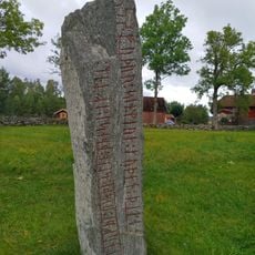
Täng 42:2, stone setting in Grästorp Municipality, Västra Götaland County, Sweden
Location: Grästorp Municipality
GPS coordinates: 58.40734,12.79502
Latest update: November 23, 2025 21:21
Västergötlands runinskrifter 108
1.2 km
Tängs kyrkoruin
1.3 km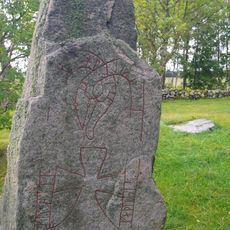
Västergötlands runinskrifter 109
1.2 km
Täng ödekyrkogård
1.2 km
Täng 2:2
1.3 km
Täng 42:3
14 m
Tun 80:1
873 m
Täng 55:2
988 m
Täng 50:1
1 km
Täng 49:1
1.3 km
Täng 47:1
276 m
Täng 34:1
653 m
Tun 16:1
1.2 km
Täng 55:1
1 km
Täng 54:1
1 km
Täng 53:1
1.2 km
Tun 63:1
1.2 km
Täng 45:1
190 m
Tun 16:2
1.1 km
Täng 42:1
15 m
Täng 47:2
254 m
Tun 17:1
825 m
Täng 46:1
505 m
Täng 50:2
1.1 km
Tun 76:1
1.1 km
Tun 79:1
1 km
Täng 41:1
339 m
Täng 40:1
363 mReviews
Visited this place? Tap the stars to rate it and share your experience / photos with the community! Try now! You can cancel it anytime.
Discover hidden gems everywhere you go!
From secret cafés to breathtaking viewpoints, skip the crowded tourist spots and find places that match your style. Our app makes it easy with voice search, smart filtering, route optimization, and insider tips from travelers worldwide. Download now for the complete mobile experience.

A unique approach to discovering new places❞
— Le Figaro
All the places worth exploring❞
— France Info
A tailor-made excursion in just a few clicks❞
— 20 Minutes