Göteborg 367, husgrund, historisk tid i Västergötland
Location: Gothenburg Municipality
GPS coordinates: 57.69008,11.82713
Latest update: June 15, 2024 10:13
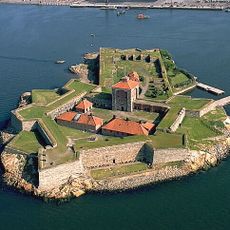
New Elfsborg Fortress
802 m
Volvo Museum
698 m
Arendal
2 km
Knippelholmen lighthouse
962 m
Älvsborgshamnen nedre
123 m
Lundby 4:1
1.7 km
Lundby 134:1
340 m
Gothenburg Inlet No 31
1.2 km
Gothenburg Inlet No 30
776 m
Lundby 1:1
726 m
Göteborg 438
294 m
Göteborg 439
54 m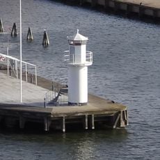
Göteborgsgrund
1.1 km
Älvsborgshamnen övre
61 m
Lundby 5:1
1.3 km
Torsviken Blue upper light
1.7 km
Torsviken Blue lower light
1.8 km
Gothenburg Inlet No 29
1.5 km
Torshamnen Red upper light
2.1 km
Lundby 132:1
118 m
Gothenburg Inlet No 27
1.8 km
Torshamnen East upper light
1.8 km
Lundby 5:2
1.4 km
Torshamnen Green upper light
1.9 km
Torshamnen East lower light
2 km
Torshamnen Green lower light
2 km
Gothenburg Inlet No 32
1 km
Gothenburg Inlet No 33
1.4 kmReviews
Visited this place? Tap the stars to rate it and share your experience / photos with the community! Try now! You can cancel it anytime.
Discover hidden gems everywhere you go!
From secret cafés to breathtaking viewpoints, skip the crowded tourist spots and find places that match your style. Our app makes it easy with voice search, smart filtering, route optimization, and insider tips from travelers worldwide. Download now for the complete mobile experience.

A unique approach to discovering new places❞
— Le Figaro
All the places worth exploring❞
— France Info
A tailor-made excursion in just a few clicks❞
— 20 Minutes