Ô Lâm, rural commune and village in An Giang, Vietnam
Location: Tri Tôn
Elevation above the sea: 20 m
GPS coordinates: 10.35170,104.97800
Latest update: November 15, 2025 05:41

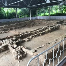
Óc Eo
24.2 km
Công viên nước Thanh Long
16.8 km
Ngã 3 Tri Tôn vào gà đốt
8.4 km
Nhà mồ Ba Chúc
18.1 km
Tho Mo Muc Cave
2.9 km
KDL Rừng Tràm Trà Sư
25.8 km
Hồ Tà Pạ
7 km
KDL Lâm Viên Núi Cấm
16.6 km
Lên 5 ông
28.1 km
Đồi tức dụp
1.2 km
Cáp treo núi cấm
17.3 km
Cáp treo núi cấm
13.8 km
TRƯỜNG ĐUA BÒ ĐỊA PHƯƠNG
26 km
Khu Di Tích Túc Dụp
3.5 km
Tra Su forest
26.7 km
Năm Giếng
27.6 km
ĐIỂM DỪNG CHÂN DƯỚI NÚI, QUÁN ĂN
5.1 km
Quán Bò leo núi
8.6 km
ĐỒNG NHÌN LÊN CHỮ TRI TÔN
6.1 km
Đua Bò Bảy Núi
6.1 km
Gà đốt Thảo Nguyên Hồ Ô Thum
2.5 km
Tượng Phật Di Lặc
17.2 km
Scenic viewpoint
28.6 km
Nghĩa trang Liệt sỹ Xã Thới Sơn
27.3 km
Ngã 3 quẹo vào
2.9 km
Tượng đài Chiến thắng Vĩnh Thông
20 km
Tượng đài Võ Văn Kiệt
21 km
Monument
20.2 kmReviews
Visited this place? Tap the stars to rate it and share your experience / photos with the community! Try now! You can cancel it anytime.
Discover hidden gems everywhere you go!
From secret cafés to breathtaking viewpoints, skip the crowded tourist spots and find places that match your style. Our app makes it easy with voice search, smart filtering, route optimization, and insider tips from travelers worldwide. Download now for the complete mobile experience.

A unique approach to discovering new places❞
— Le Figaro
All the places worth exploring❞
— France Info
A tailor-made excursion in just a few clicks❞
— 20 Minutes