Tà Nung, Landgemeinde in Vietnam
Location: Đà Lạt
Elevation above the sea: 1,163 m
GPS coordinates: 11.91556,108.35861
Latest update: November 15, 2025 05:39

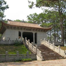
Nguyen Huu Hao Mausoleum
6.9 km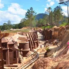
Dalat Clay Tunnel
6.8 km
Tượng Đức Mẹ
7 km
Thác Cam Ly
7.3 km
Kho
1.6 km
Kaffe plantage
4.9 km
Lavander Dalat Garden
7.2 km
Garnet Cellar Farden
7.4 km
Mongo Land Dalat
2.1 km
Nice park area
3.2 km
Hầm rượu du lịch
7.4 km
Làng hoa vạn thành mới
6.5 km
Cabin of Our Lady
7.2 km
Lều chụp hình
1.9 km
Clay Tunnels - Dalat Star
6.8 km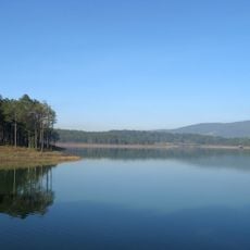
Tuyền Lâm Lake
7.7 km
Scenic viewpoint
5.3 km
Củi khô
7.6 km
Củi khô
7.5 km
Nhà thờ Camly
7.6 km
Vườn Hoa Tam Giác Mạch, Hoa Cải
2.1 km
Scenic viewpoint
5.9 km
Statue
7.5 km
Modern castle's ruin
6.8 km
View point
2 km
Thác bảo đại ; làng xì trum
7.4 km
Thác Vọng
2.6 km
Waterfall
7.6 kmReviews
Visited this place? Tap the stars to rate it and share your experience / photos with the community! Try now! You can cancel it anytime.
Discover hidden gems everywhere you go!
From secret cafés to breathtaking viewpoints, skip the crowded tourist spots and find places that match your style. Our app makes it easy with voice search, smart filtering, route optimization, and insider tips from travelers worldwide. Download now for the complete mobile experience.

A unique approach to discovering new places❞
— Le Figaro
All the places worth exploring❞
— France Info
A tailor-made excursion in just a few clicks❞
— 20 Minutes