
Alter Ortskern Hallgarten
Location: Oestrich-Winkel
Address: Gesamtanlage
GPS coordinates: 50.02742,8.03090
Latest update: November 23, 2025 08:35
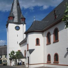
Mariae Himmelfahrt
27 m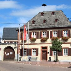
Ehem. Rathaus
14 m
Haus Zangerstraße 12
25 m
Haus Zangerstraße 11
50 m
Haus Zangerstraße 7
26 m
Haus Zangerstraße 4
45 m
Haus Zangerstraße 8
40 m
Haus Zangerstraße 10
26 m
Haus Zangerstraße 11a
49 m
Haus Taunusstraße 4
58 m
Haus Taunusstraße 11
57 m
Haus Taunusstraße 2
54 m
Haus Taunusstraße 7
52 m
Haus Zangerstraße 6
40 m
Haus Taunusstraße 3
24 m
Haus Taunusstraße 5
34 m
Haus Zangerstraße 18
45 m
Haus Zangerstraße 20
56 m
Haus Taunusstraße 9
65 m
Haus Zangerstraße 14
28 m
Haus Zangerstraße 16
31 m
Haus Zangerstraße 9
37 m
Haus Zangerstraße 13
62 m
Inschrift 1581 (Sachteil)
61 m
Weingut Riedel
13 m
Kreuzigungsgruppe
49 m
Alte Schule
52 m
Wayside cross
49 mReviews
Visited this place? Tap the stars to rate it and share your experience / photos with the community! Try now! You can cancel it anytime.
Discover hidden gems everywhere you go!
From secret cafés to breathtaking viewpoints, skip the crowded tourist spots and find places that match your style. Our app makes it easy with voice search, smart filtering, route optimization, and insider tips from travelers worldwide. Download now for the complete mobile experience.

A unique approach to discovering new places❞
— Le Figaro
All the places worth exploring❞
— France Info
A tailor-made excursion in just a few clicks❞
— 20 Minutes