
Reste der ehem. Zahnradbahn, هيكل معماري في روديشيم أم راين، ألمانيا
Location: Rüdesheim am Rhein
Address: BischofsbergRheinstraßeHolzwegDrachensteinAuf dem Niederwald
GPS coordinates: 49.98495,7.91337
Latest update: June 14, 2024 18:22
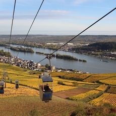
Seilbahn Rüdesheim
429 m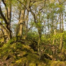
Naturschutzgebiet Ebental bei Rüdesheim
497 m
Gutmann'scher Bildstock
748 m
Ebental bei Rüdesheim
763 m
Fischbachs-Kreuz
737 m
Kreuz am Scheideweg
707 m
Haus Oberstraße 17
746 m
Metternich'scher Bildstock
593 m
Haus Oberstraße 13
744 m
Haus Oberstraße 11
742 m
Haus Oberstraße 2
706 m
Ingelheim'sches Kreuz
759 m
Kreuz Dornenkron
667 m
Rüdesheimer Kuhweg
523 m
Wayside shrine, Christianity
596 m
Stauderhanser Heiligenhäuschen
688 m
Wayside cross, Christianity, Catholic church building
707 m
Ingelheimer - Blick
648 m
Scenic viewpoint
623 m
Wayside cross, Christianity
604 m
Wayside shrine, Christianity
698 m
Wayside cross
495 m
Catholic church building, wayside cross, Christianity
344 m
Frankensteiner Hof
751 m
Gutsschenke Feldtor / Weingut Müller
753 m
Wayside cross
759 m
Wayside shrine
200 m
Metternicher Hof
761 mReviews
Visited this place? Tap the stars to rate it and share your experience / photos with the community! Try now! You can cancel it anytime.
Discover hidden gems everywhere you go!
From secret cafés to breathtaking viewpoints, skip the crowded tourist spots and find places that match your style. Our app makes it easy with voice search, smart filtering, route optimization, and insider tips from travelers worldwide. Download now for the complete mobile experience.

A unique approach to discovering new places❞
— Le Figaro
All the places worth exploring❞
— France Info
A tailor-made excursion in just a few clicks❞
— 20 Minutes