Ehem. Forsthaus, هيكل معماري في ألمانيا
Location: Eltville am Rhein
Address: Wiesweg 91
GPS coordinates: 50.04739,8.09474
Latest update: June 13, 2024 18:10

Kreuz am Langenstück
525 m
Haus Tränkweg 7
921 m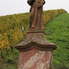
Hl. Franz Xaver
503 m
Grabstätte August F. K. Martin
924 m
Haus Tränkweg 6
914 m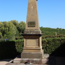
Kriegerdenkmal 1870-71
869 m
Haus Mühlbergstraße 4b
924 m
Haus Tränkweg 5
906 m
Kreuz an der Rausch
597 m
Friedhofskreuz
919 m
Grenzstein und Wegekreuz
558 m
Heiligenstock, Kreuz im Heiligenstock
789 m
Wayside cross
679 m
Wayside cross
557 m
Weinbergshäuschen
768 m
Wayside shrine, Christianity
771 m
Wayside cross
783 m
Wayside shrine, Christianity
598 m
Sehstele
813 m
Gräfenberg
850 m
Eberbacher Klostermühle
864 m
Catholic church building, wayside shrine, Christianity
660 m
Weinbergsweg
557 m
Wayside cross
525 m
Francisco Xaverio Divo
508 m
Heiligenstock
437 m
Wayside cross
406 m
Scenic viewpoint
290 mReviews
Visited this place? Tap the stars to rate it and share your experience / photos with the community! Try now! You can cancel it anytime.
Discover hidden gems everywhere you go!
From secret cafés to breathtaking viewpoints, skip the crowded tourist spots and find places that match your style. Our app makes it easy with voice search, smart filtering, route optimization, and insider tips from travelers worldwide. Download now for the complete mobile experience.

A unique approach to discovering new places❞
— Le Figaro
All the places worth exploring❞
— France Info
A tailor-made excursion in just a few clicks❞
— 20 Minutes