9-13, High Street, building in Chevening, Sevenoaks, Kent, UK
Location: Chevening
Address: 9-13, High Street, Chevening, Sevenoaks, Kent, TN13
GPS coordinates: 51.28451,0.15123
Latest update: November 25, 2023 00:28
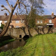
East Side Of Bridge Over River Darenth
156 m
K6 Telephone Kiosk
75 m
Crown House
28 m
5, High Street
38 m
Vine Cottage
42 m
1 and 3, Chevening Road
84 m
Forecourt Wall To Nos 2 To 16
54 m
Old Butcher's Shop
56 m
2-16, High Street
59 m
Chipstead Chapel
61 m
1-7, Stairfoot Lane
66 m
Wall on South West Side
70 m
Walls On North East Side
74 m
17, High Street
32 m
22-26, High Street
31 m
30 And 32, High Street
46 m
29 And 31, High Street
89 m
Screen Wall To North Of No 3 And Around Corner Along South East Side Of Approach To Mill House
90 m
Forecourt Wall To West Of The Rock House
91 m
Stable Buildings And Cobbled Yard To West Of The Rock House
97 m
The Home Farmhouse
100 m
The Rock House
112 m
15-21, Chevening Road
122 m
Bank House
131 m
Hollyhock
81 m
The George And Dragon Public House
160 m
Mill House
163 m
Wall To East Of Bank House
183 mReviews
Visited this place? Tap the stars to rate it and share your experience / photos with the community! Try now! You can cancel it anytime.
Discover hidden gems everywhere you go!
From secret cafés to breathtaking viewpoints, skip the crowded tourist spots and find places that match your style. Our app makes it easy with voice search, smart filtering, route optimization, and insider tips from travelers worldwide. Download now for the complete mobile experience.

A unique approach to discovering new places❞
— Le Figaro
All the places worth exploring❞
— France Info
A tailor-made excursion in just a few clicks❞
— 20 Minutes