Paynes Place, building in Ansty and Staplefield, Mid Sussex, West Sussex, UK
Location: Ansty and Staplefield
GPS coordinates: 50.97661,-0.15400
Latest update: November 9, 2025 10:08
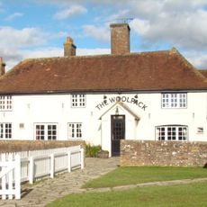
The Woolpack Public House
1.5 km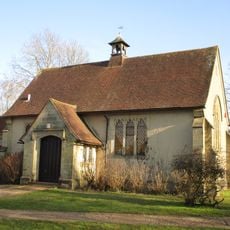
St Edward the Confessor
1.8 km
Mount Noddy Cottage
1.8 km
Barn At Bishopstone Farm
1.5 km
Hilders Cottage
1.5 km
Rock Cottage
1.5 km
Sheddingdean Farmhouse
2 km
The Ancient Farm
2 km
Firlands
1.3 km
Barn Approximately 40 Metres South East Of Legh Manor
1.2 km
Hook House Farmhouse
1.4 km
Chapel Farmhouse
1.6 km
Lye's Farmhouse
687 m
Sick Cow Barn At Bishopstone Farm
1.5 km
Little Lower Ease
1 km
Legh Manor
1.3 km
Butler's Farmhouse
2 km
Harvesthill
1.2 km
West Riddens Farmhouse
1.5 km
Lower Ridges
897 m
Upper Ridges Moonhill Place
1.5 km
Grasmere
1.9 km
The Place
2 km
Barn To The South West Of Lower Ridges
876 m
Barn To The West Of Lye's Farmhouse
669 m
The Sportsman Inn
1.7 km
Burgess Hill Golf Centre
997 m
Work of art, sculpture
1.8 kmReviews
Visited this place? Tap the stars to rate it and share your experience / photos with the community! Try now! You can cancel it anytime.
Discover hidden gems everywhere you go!
From secret cafés to breathtaking viewpoints, skip the crowded tourist spots and find places that match your style. Our app makes it easy with voice search, smart filtering, route optimization, and insider tips from travelers worldwide. Download now for the complete mobile experience.

A unique approach to discovering new places❞
— Le Figaro
All the places worth exploring❞
— France Info
A tailor-made excursion in just a few clicks❞
— 20 Minutes