Trees, building in Wye with Hinxhill, Ashford, Kent, UK
Location: Wye with Hinxhill
GPS coordinates: 51.14342,0.92697
Latest update: November 23, 2025 22:50
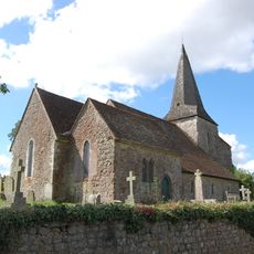
Church of St Mary
312 m
Rock Cottages
549 m
Bockham Farm Cottage
979 m
146,148,150, The Street
999 m
Lacton Farmhouse
1 km
Barn To South East Of Lacton Farmhouse
1 km
Oast House To East Of Lacton Farmhouse
997 m
Barn/Stable Block At Little Plumpton (Tr 053429)
727 m
Chest Tomb And 2 Headstones About 1 Metre South Of Church Of St Mary
304 m
Barn About 20 Metres North Of Goodcheap Farmhouse
1 km
Lychgate, Side Gate And Churchyard Walls To Churchyard Of Church Of St Mary
327 m
Plumpton Farmhouse And Garden Walls
875 m
124 And 126, The Street
914 m
Walnut Tree House
1.1 km
The Street House
1.1 km
Elm Cottage And Bakehouse Attached
1.1 km
Goodcheap Farmhouse And Wall Projecting
999 m
Court Lodge And Garden Wall
267 m
Little Folly
955 m
130,132,134, The Street
933 m
81, The Street
1.1 km
Summerhill
1.1 km
121,123, The Street
1 km
Ouseley Farmhouse
154 m
Milestone At Tr 045 412
1.2 km
The Blacksmith's Arms Public House
1.1 km
Tollgate Cottage
1 km
Statue of William Harvey
809 mReviews
Visited this place? Tap the stars to rate it and share your experience / photos with the community! Try now! You can cancel it anytime.
Discover hidden gems everywhere you go!
From secret cafés to breathtaking viewpoints, skip the crowded tourist spots and find places that match your style. Our app makes it easy with voice search, smart filtering, route optimization, and insider tips from travelers worldwide. Download now for the complete mobile experience.

A unique approach to discovering new places❞
— Le Figaro
All the places worth exploring❞
— France Info
A tailor-made excursion in just a few clicks❞
— 20 Minutes