78 And 79, building in Kington St. Michael, Wiltshire, UK
Location: Kington St Michael
GPS coordinates: 51.49482,-2.13942
Latest update: November 16, 2025 22:35
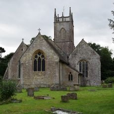
Church of St Michael
141 m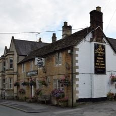
The Jolly Huntsman Inn
29 m
Three Monuments In Churchyard To North East Of Chancel Of Church Of St Michael
120 m
Hazeland House
580 m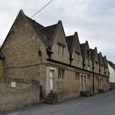
The Lyte Almshouses
21 m
Kington Manor
198 m
31
554 m
3 And 3A
64 m
22
48 m
75
11 m
Gate Piers To The Manor House
103 m
Home Farmhouse
89 m
Group Of Three Chest Tombs Standing On The South Side Of The Footpath To The South Of The South Aisle Of The Church Of St Michael
153 m
86-89
136 m
Barn And Stable At Manor Farm
299 m
53-55, Kington St Michael
241 m
8-10, Kington St Michael Village
39 m
The Old Police House
19 m
Lychgate At West Entrance To Churchyard Of Church Of St Michael
103 m
Barn At Lodge Farm
954 m
23
70 m
Group Of Nine Monuments In Churchyard South West Of South Aisle Of Church Of St Michael
154 m
66-68
65 m
K6 Telephone Kiosk
69 m
Two Unidentified Monuments In Churchyard About 11 Metres North Of North Aisle Of Church Of St Michael
123 m
Group Of Three Monuments In Churchyard About 12 Metres South West Of Porch Of Church Of St Michael
162 m
The Old Rectory
228 m
Manor Farmhouse
273 mReviews
Visited this place? Tap the stars to rate it and share your experience / photos with the community! Try now! You can cancel it anytime.
Discover hidden gems everywhere you go!
From secret cafés to breathtaking viewpoints, skip the crowded tourist spots and find places that match your style. Our app makes it easy with voice search, smart filtering, route optimization, and insider tips from travelers worldwide. Download now for the complete mobile experience.

A unique approach to discovering new places❞
— Le Figaro
All the places worth exploring❞
— France Info
A tailor-made excursion in just a few clicks❞
— 20 Minutes