32, building in Wootton St. Lawrence, Basingstoke and Deane, Hampshire, UK
Location: Wootton St Lawrence
GPS coordinates: 51.28809,-1.16973
Latest update: November 23, 2025 02:29
Christ Church
3 km
Church of All Saints
3.1 km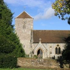
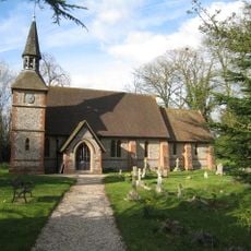
Church of St. Lawrence
1.9 km
Malshanger House
2.4 km
Crocus Cottage
2.9 km
Tangier House
1.5 km
Crabwood Cottage
38 m
Kitchen Garden Wall Immediately West Of Ewhurst House
2.3 km
Stable Block And House Immeadiately North West Of Church Of St Mary
2.4 km
Malshanger Farmhouse
2.3 km
May's Farmhouse
2.4 km
Roman site NW of Woodgarston Farm
1.2 km
Keyhole enclosure SE of Field Barn Farm
2.1 km
Manor Farmhouse
1.8 km
Lower Farm Barn
2 km
Woodgarston ring motte
619 m
Wellhouse
2.4 km
Barn At Digweeds Farm
2.6 km
Walnut Tree Cottage
181 m
Primmers
2.1 km
Stable Block And Tower, With Part Of Kitchen Garden Wall (Malshanger Castle Remains)
2.4 km
Top House
74 m
Granary Adjoining Lower Farm Barn To The South
2 km
Skyers Farm Barn
2.6 km
Church of St Mary
2.3 km
Bailey Hall Farmhouse
1.5 km
Digweeds Farmhouse
2.6 km
Maize Maze
2.9 kmReviews
Visited this place? Tap the stars to rate it and share your experience / photos with the community! Try now! You can cancel it anytime.
Discover hidden gems everywhere you go!
From secret cafés to breathtaking viewpoints, skip the crowded tourist spots and find places that match your style. Our app makes it easy with voice search, smart filtering, route optimization, and insider tips from travelers worldwide. Download now for the complete mobile experience.

A unique approach to discovering new places❞
— Le Figaro
All the places worth exploring❞
— France Info
A tailor-made excursion in just a few clicks❞
— 20 Minutes