Old Stable Block, architectural structure in Sherborne St. John, Basingstoke and Deane, Hampshire, UK
Location: Sherborne St John
GPS coordinates: 51.30708,-1.08776
Latest update: November 25, 2023 00:30
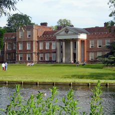
The Vyne
44 m
165,166, Vyne Road
903 m
Beaurepaire House
1.4 km
162,163,164, Vyne Road
968 m
Barn, And Cartshed 30 Yards East Of The House
1.4 km
Cufaude Farmhouse
1.4 km
Beaurepaire House Gatepiers
1.3 km
Garden walls
292 m
North Lodge
323 m
18,20, Vyne Road
1.8 km
The Beeches
655 m
Beech Lodge
665 m
Moated site west of Cufaude Farm
1.3 km
Granary, 20 Yards East Of The House
1.4 km
Vyne Farmhouse
265 m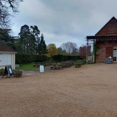
Stable Block
54 m
Garden Pavilion
106 m
South Lodge
473 m
Gate-Piers, And Rails
134 m
168,169 And 170, Vyne Road
629 m
100 Guinea tree
118 m
Iron Bridge
246 m
Suspension Bridge
1.3 km
Bakers Farmhouse
1.6 km
Hillend Farmhouse
1.7 km
Beaurepaire Mill House
1.7 km
Beaurepaire Mill
1.7 km
Beaurepaire Mill Bridge
1.7 kmReviews
Visited this place? Tap the stars to rate it and share your experience / photos with the community! Try now! You can cancel it anytime.
Discover hidden gems everywhere you go!
From secret cafés to breathtaking viewpoints, skip the crowded tourist spots and find places that match your style. Our app makes it easy with voice search, smart filtering, route optimization, and insider tips from travelers worldwide. Download now for the complete mobile experience.

A unique approach to discovering new places❞
— Le Figaro
All the places worth exploring❞
— France Info
A tailor-made excursion in just a few clicks❞
— 20 Minutes