
Snowball Headstone Approx 10 Yards South Of Church Of St Andrew
Snowball Headstone Approx 10 Yards South Of Church Of St Andrew, tombstone in Belsay, Northumberland, UK
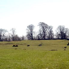
Defended settlement on Slate Hill, 300m north west of Bolam Lake
1.6 km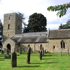
Church of St Andrew
16 m
Remains Of Cross Approx 15 Yards South Of Church Of St Andrew
8 m
Bridge Approx 440 Yards East Of Shortflatt Tower
1.7 km
Bridge On Track From Low Angerton To Howlet Hall
1.7 km
Bolam Castle
680 m
Gate Piers And Walls Approx 300 Yards South-East Of Bolam Hall
431 m
Bastle 40m north east of Low Angerton
1.8 km
Cook, Hepple, Steel, Renwick And Crow Headstones Approx 2-8 Yards South Of Church Of St Andrew
9 m
Folly Farmhouse And Attatched Barn
2.1 km
Meldon Lane House
1.9 km
Dovecote And Outbuilding Approx 30 Yards North Of Bolam Hall
532 m
Mounting Block Approx 20 Yards South Of Church Of St Andrew
22 m
Bowman And Morgan Headstones Approx 20 Yds South Of Church Of St Andrew
15 m
Anderson, Colley And 2 Other Headstones Approx 2-10 Yards South Of Church Of St Andrew
13 m
Gateway And Churchyard Wall To South Of Church Of St Andrew
25 m
Farmbuildings To North Of Meldon Lane House
1.8 km
Defended settlement, 200m south west of Bolam Hall
683 m
Round cairn, 400m SSW of Bolam church
393 m
Huckhoe palisaded enclosure, defended settlement and Romano-British settlement, 550m north east of Bolam West Houses
2 km
Low Angerton Bridges Over River Wansbeck
1.7 km
Low Angerton Farmhouse And Outbuildings To East
1.7 km
Armorial Beast Approx 10 Yds East Of Shortflatt Tower
2 km
Bolam Hall East Wing, And Bolam Hall West Wing
519 m
Wall And Gatepiers And Gate Approximately 350 Yards South West Of Bolam Hall
806 m
Robson Headstone Approx 15 Yards South Of Church Of St Andrew
11 m
The Old Vicarage
60 m
Garden Gates Approx 30 Yards East Of Shortflatt Tower
2 kmReviews
Visited this place? Tap the stars to rate it and share your experience / photos with the community! Try now! You can cancel it anytime.
Discover hidden gems everywhere you go!
From secret cafés to breathtaking viewpoints, skip the crowded tourist spots and find places that match your style. Our app makes it easy with voice search, smart filtering, route optimization, and insider tips from travelers worldwide. Download now for the complete mobile experience.

A unique approach to discovering new places❞
— Le Figaro
All the places worth exploring❞
— France Info
A tailor-made excursion in just a few clicks❞
— 20 Minutes