K6 Telephone Kiosk, K6 telephone box in Avening, Cotswold, Gloucestershire, UK
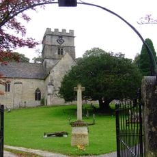
Church of the Holy Cross, Avening
343 m
Unidentified Memorial, About 12 Metres North West Of Porch In The Churchyard Of Church Of Holy Cross
365 m
Group Of 3 Unidentified Memorials About 15 Metres North West Of Porch In Churchyard Of Church Of The Holy Cross
367 m
Unidentified Memorial, About 16 Metres North West Of Porch In Churchyard Of Church Of Holy Cross
362 m
Barrett Memorial, About 21 Metres West Of Porch In Churchyard Of Church Of The Holy Cross
381 m
Glebe House
243 m
Sandford House
237 m
Old Quarries
341 m
2 And 4, Rectory Lane
321 m
Brook House
274 m
The Old Rectory
375 m
54, High Street
281 m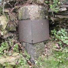
Milestone, Tetbury Hill, S village
166 m
Hanslo House
16 m
20, Woodstock Lane
516 m
Mullions, Adjacent To Churchyard Of Church Of Holy Cross On West Side, And Garden Wall
353 m
Unidentified Memorial, About 15 Metres North West Of Porch In Churchyard Of Church Of The Holy Cross
363 m
Unidentified Memorial, About 7 Metres South West Of Doorway In Churchyard Of Avening Baptist Chapel
90 m
25, Point Road
241 m
Cartshed With Granary Over And Attached Cow Shelter Adjoining Church Farmhouse On West
394 m
Church Farmhouse
370 m
Water Pump, By The Shoe Box
25 m
Water Pump, Located In The Fork At The Top Of Lane
400 m
Water Pump, By The Old Garage At Bottom Of Lane
501 m
Water Pump, In The Fork Of The Side Road On The Left
94 m
Water Pump, Halfway Along, On The Left
132 m
Water Pump, Next To The Bell Inn
240 m
Barn at Church Farm, on West Side of Farmyard
406 mReviews
Visited this place? Tap the stars to rate it and share your experience / photos with the community! Try now! You can cancel it anytime.
Discover hidden gems everywhere you go!
From secret cafés to breathtaking viewpoints, skip the crowded tourist spots and find places that match your style. Our app makes it easy with voice search, smart filtering, route optimization, and insider tips from travelers worldwide. Download now for the complete mobile experience.

A unique approach to discovering new places❞
— Le Figaro
All the places worth exploring❞
— France Info
A tailor-made excursion in just a few clicks❞
— 20 Minutes