Building 24, building in Stanton St. Quintin, Wiltshire, UK
Location: Stanton St Quintin
GPS coordinates: 51.52862,-2.13034
Latest update: November 16, 2025 20:12
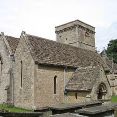
Church of St Giles
1.3 km
North Barn To Former Bell Farm At Raf Hullavington At Ngr 912812
169 m
Barn At Manor Farm
1.3 km
South Barn To Former Bell Farm At Raf Hullavington At Ngr 912812
146 m
Glebe Farmhouse And Privy
880 m
Lower Stanton Farmhouse
690 m
Lychgate At Entry To Churchyard Of Church Of St Giles
1.3 km
Building 66 (Guard And Firehouse)
322 m
Building 79 (Mt Group)
322 m
Building 25 (Central Heating Plant)
68 m
Building 30 (Works Services Building And Water Tower)
90 m
Building 32 (Station Church)
210 m
Buildings 43, 46, 48 And 50 (Type Q Barracks)
142 m
Buildings 59, 60 And 61 (Officers Mess)
408 m
Building 4 (Control Tower)
160 m
Entrance Gates, Piers And Walls To South Of Officers Mess
506 m
Main Gates, Piers And Railings
364 m
Buildings 3, 6 And 7 ('C' Type Hangars)
105 m
Two Monuments In Churchyard North Of Tower Of Church Of St Giles
1.3 km
Building 81 (Station Staff Offices)
260 m
Building 80 (Qm Stores)
389 m
Building 82 (Canteen), Aircraft Storage Unit Site
373 m
Building 23 (Parachute Store)
218 m
School Cottage
1.2 km
Building 22
103 m
Building 75 (C-Type Hangar), Aircraft Storage Unit Site
399 m
Building 77 (Guardhouse), Aircraft Storage Unit Site
248 m
Building 20 (Main Stores)
163 mReviews
Visited this place? Tap the stars to rate it and share your experience / photos with the community! Try now! You can cancel it anytime.
Discover hidden gems everywhere you go!
From secret cafés to breathtaking viewpoints, skip the crowded tourist spots and find places that match your style. Our app makes it easy with voice search, smart filtering, route optimization, and insider tips from travelers worldwide. Download now for the complete mobile experience.

A unique approach to discovering new places❞
— Le Figaro
All the places worth exploring❞
— France Info
A tailor-made excursion in just a few clicks❞
— 20 Minutes