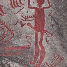
Brastad 2:1, hällristning i Bohuslän
Location: Lysekil Municipality
GPS coordinates: 58.40201,11.48908
Latest update: November 23, 2025 15:21
Backa petroglyph area
88 m
Brastad 46:4
257 m
Brastad 11:2
275 m
Brastad 13:1
322 m
HKH Kronprinsessan Victorias hällristning
130 m
Brastad 596
194 m
Brastad 594
341 m
Brastad 588
231 m
Brastad 47:1
245 m
Brastad 4:1
127 m
Brastad 16:1
444 m
Skomakaren
88 m
Brastad 589
187 m
Brastad 6:1
260 m
Brastad 46:1
259 m
Brastad 1:2
100 m
Tulleberget
388 m
Brastad 48:1
230 m
Brastad 47:2
241 m
Brastad 33:1
375 m
Brastad 9:1
38 m
Brastad 11:1
279 m
Brastad 32:1
385 m
Brastad 604
425 m
Brastad 14:1
416 m
Brastad 15:1
430 m
Brastad 586
261 m
Brastad 19:1
427 mReviews
Visited this place? Tap the stars to rate it and share your experience / photos with the community! Try now! You can cancel it anytime.
Discover hidden gems everywhere you go!
From secret cafés to breathtaking viewpoints, skip the crowded tourist spots and find places that match your style. Our app makes it easy with voice search, smart filtering, route optimization, and insider tips from travelers worldwide. Download now for the complete mobile experience.

A unique approach to discovering new places❞
— Le Figaro
All the places worth exploring❞
— France Info
A tailor-made excursion in just a few clicks❞
— 20 Minutes