
Prehistoric linear boundary at Crown Tegleaze, 1km north west of Littleton Farm
Prehistoric linear boundary at Crown Tegleaze, 1km north west of Littleton Farm, archaeological site in East Lavington, Chichester, England, UK
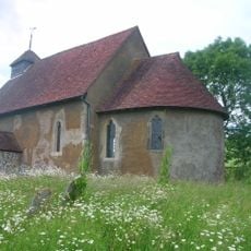
St Mary The Virgin, Upwaltham
1.3 km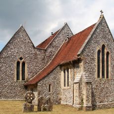
The Parish Church of St Peter
1.1 km
Garden Balustrade And Gate Piers At Lavington Park To The North Of The House
1.3 km
Willow Cottage
1.3 km
Upwaltham Cottage
1.6 km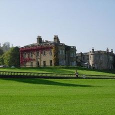
Lavington Park
1.2 km
Bowl barrow on Waltham Down, 320 ESE of crossroads: part of Waltham Down round barrow cemetery
1.5 km
Bell barrow south-west of Heath Hanger: part of Waltham Down round barrow cemetery
1.5 km
Beechwood
1.2 km
Barn at Church Farm to the North of the Farmhouse
1.3 km
The Former Stables Of Lavington Park, Now Part Of Seaford Collage To The West Of The House
1.2 km
Two bowl barrows on Waltham Down, 115m east of crossroads: part of Waltham Down round barrow cemetery
1.7 km
Church Farmhouse
1.4 km
Littleton Farmhouse
966 m
Cross dyke on Upwaltham Hill, 500m and 620m south east of Upwaltham Farm
1.8 km
Bowl barrow on Waltham Down, 200m east of cross roads: part of Waltham Down round barrow cemetery
1.6 km
Bowl barrow on Barlavington Down
1.9 km
Beech Cottage
1.2 km
63 And 64, High Street
2 km
Mallowes
1.9 km
Bowl barrow on Woolavington Down
390 m
Prehistoric linear boundary on Barlavington Down, 550m north east of Dog Kennels
1.8 km
Cross dyke on Woolavington Down, 600m south of Lavington House
655 m
Cross dyke on Woolavington Down, 625m east of Tegleaze Farm
604 m
Cross dyke on Woolavington Down, 475m north east of Tegleaze Farm
1 km
Bowl barrow on Woolavington Down north-east of Stickingspit Bottom
692 m
Seaford College Golf Academy
1.7 km
Dunction Hill
1.5 kmReviews
Visited this place? Tap the stars to rate it and share your experience / photos with the community! Try now! You can cancel it anytime.
Discover hidden gems everywhere you go!
From secret cafés to breathtaking viewpoints, skip the crowded tourist spots and find places that match your style. Our app makes it easy with voice search, smart filtering, route optimization, and insider tips from travelers worldwide. Download now for the complete mobile experience.

A unique approach to discovering new places❞
— Le Figaro
All the places worth exploring❞
— France Info
A tailor-made excursion in just a few clicks❞
— 20 Minutes