Townfield House

Log in to your account

AroundUs is a community-driven map of interesting places, built by curious explorers like you. It grows with every review, story, and photo you share.
Connect to save your favorite spots, contribute locations, and create personalized routes.
By continuing, you accept our Terms and Conditions and our Privacy Policy
Add to collection
Map
Suggest a change
Share

Townfield House, house in Hunstanworth, County Durham, UK
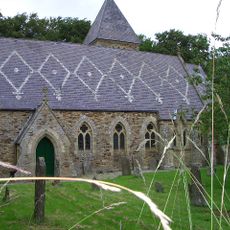
Location: Hunstanworth

GPS coordinates: 54.83039,-2.07758

Latest update: December 1, 2025 17:52

Around this place
Show the full map
Church of St James
United Kingdom

Church of St James

658 m
Townfield Cottages
United Kingdom

Townfield Cottages

75 m
South View Cottage  The Cottage
United Kingdom

South View Cottage The Cottage

641 m
Corner Cottage  Mansion Cottage
United Kingdom

Corner Cottage Mansion Cottage

655 m
Walls On North Side Of Village Street In Front Of South View, Woodside Cottage, The Cottage, Mansion Cottage, Corner Cottage And The Vicarage, With Gate Piers And Gates
United Kingdom

Walls On North Side Of Village Street In Front Of South View, Woodside Cottage, The Cottage, Mansion Cottage, Corner Cottage And The Vicarage, With Gate Piers And Gates

640 m
Outbuilding North Of Townfield House
United Kingdom

Outbuilding North Of Townfield House

14 m
Giant's Stride, West Of The Old School, In Former Schoolyard
United Kingdom

Giant's Stride, West Of The Old School, In Former Schoolyard

17 m
Lead mining remains at Ramshaw
United Kingdom

Lead mining remains at Ramshaw

1.1 km
Hunstanworth Farmhouse
United Kingdom

Hunstanworth Farmhouse

652 m
Hunstanworth Farm West Range
United Kingdom

Hunstanworth Farm West Range

667 m
Stable Block Of Former Vicarage
United Kingdom

Stable Block Of Former Vicarage

762 m
Hunstanworth Farm East Byre Range
United Kingdom

Hunstanworth Farm East Byre Range

674 m
The Old School
United Kingdom

The Old School

30 m
Tower house in the churchyard of St James's Church
United Kingdom

Tower house in the churchyard of St James's Church

655 m
Courtyard And Orchard Walls In  Front Of Stable Block
United Kingdom

Courtyard And Orchard Walls In Front Of Stable Block

756 m
Walls Enclosing Garden And Yard Of Townfield House
United Kingdom

Walls Enclosing Garden And Yard Of Townfield House

30 m
Walls, Piers And Gates Enclosing Yard Of Church Of St James
United Kingdom

Walls, Piers And Gates Enclosing Yard Of Church Of St James

667 m
Moor View (House Opposite Church, Shown As Os Map As Shangri La)
United Kingdom

Moor View (House Opposite Church, Shown As Os Map As Shangri La)

603 m
School House
United Kingdom

School House

42 m
Mill Cottage And House Adjoining At Jamieson's Mill
United Kingdom

Mill Cottage And House Adjoining At Jamieson's Mill

928 m
Walls And Gate In Front Of Hunstanworth Farma Nd Farmhouse
United Kingdom

Walls And Gate In Front Of Hunstanworth Farma Nd Farmhouse

666 m
Former School And House Attached (Old Church House)
United Kingdom

Former School And House Attached (Old Church House)

592 m
Walls On South Side Of Village Street In Front Of Ivy Cottage, Moor View And Old Church House
United Kingdom

Walls On South Side Of Village Street In Front Of Ivy Cottage, Moor View And Old Church House

624 m
Hunstanworth Farm North Range
United Kingdom

Hunstanworth Farm North Range

689 m
Range To East Of Hunstanworth Farm East Byre Range
United Kingdom

Range To East Of Hunstanworth Farm East Byre Range

693 m
Walls Around Former Schoolyard, And Letter Box
United Kingdom

Walls Around Former Schoolyard, And Letter Box

53 m
West End, Pine Cottage And Ivy Cottage, With Area Wall And Gates
United Kingdom

West End, Pine Cottage And Ivy Cottage, With Area Wall And Gates

626 m
Former Vicarage With Terrace Retaining Wall And Steps
United Kingdom

Former Vicarage With Terrace Retaining Wall And Steps

760 m
Show the full map

Reviews

Visited this place? Tap the stars to rate it and share your experience / photos with the community! Try now! You can cancel it anytime.

« Townfield House - house in Hunstanworth, County Durham, UK » is provided by Around Us (aroundus.com). Images and texts are derived from Wikimedia project under a Creative Commons license. You are allowed to copy, distribute, and modify copies of this page, under the conditions set by the license, as long as this note is clearly visible.

Discover hidden gems everywhere you go!

From secret cafés to breathtaking viewpoints, skip the crowded tourist spots and find places that match your style. Our app makes it easy with voice search, smart filtering, route optimization, and insider tips from travelers worldwide. Download now for the complete mobile experience.

Around Us App Screenshot

A unique approach to discovering new places

Le Figaro

All the places worth exploring

France Info

A tailor-made excursion in just a few clicks

20 Minutes