Lambton Bridge, road bridge in Chester-le-Street
Location: County Durham
Inception: 1926
GPS coordinates: 54.86406,-1.55786
Latest update: November 25, 2023 00:46

Lumley Castle
1.1 km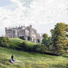
Lambton Castle
1.4 km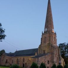
St Mary and St Cuthbert, Chester-le-Street
1.3 km
Concangis
1.2 km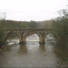
Chester New Bridge
61 m
United Reformed Church
1.3 km
Brewery House
1.3 km
Brewery Cottages
1.1 km
Gates, Piers And Walls, North-West Of Lumley Lodge
340 m
Iron Gates, Posts And Railings 200 Metres North West Of Lambton Castle
1.3 km
Terrace Retaining Wall, South Of Lambton Castle
1.4 km
Gateway To North-West Of Chester Lodge
85 m
Former Dairy, Loggia, Rear Yard Walls And Outbuilding To North Of Lambton Castle
1.5 km
Milestone, North Road
1.3 km
Sculpture, Work of art
895 m
Sundial 20 Metres West Of Lumley Castle
1.2 km
Ankers House Museum
1.3 km
HMS Clare
1.2 km
Cade's Road
1.3 km
Chester-le-Street Golf Club
997 m
Piers, Walls And Gates, 60 Metres West Of Harraton Lodge
1.3 km
Statue, Work of art
1.3 km
Lamb Bridge
980 m
Queens Head Hotel
1.4 km
New Lumley Bridge
1.4 km
2 Arcaded Garden Walls, Piers And Stone Lions To North And West Of Lambton Castle
1.4 km
Installation artwork, Work of art
758 m
A1(M) bridge over the Wear
294 mReviews
Visited this place? Tap the stars to rate it and share your experience / photos with the community! Try now! You can cancel it anytime.
Discover hidden gems everywhere you go!
From secret cafés to breathtaking viewpoints, skip the crowded tourist spots and find places that match your style. Our app makes it easy with voice search, smart filtering, route optimization, and insider tips from travelers worldwide. Download now for the complete mobile experience.

A unique approach to discovering new places❞
— Le Figaro
All the places worth exploring❞
— France Info
A tailor-made excursion in just a few clicks❞
— 20 Minutes