Orchard Dale, architectural structure in Storrington and Sullington, Horsham, West Sussex, UK
Location: Storrington and Sullington
GPS coordinates: 50.91670,-0.45553
Latest update: November 25, 2023 00:49
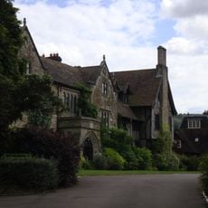
The Abbey, Storrington
190 m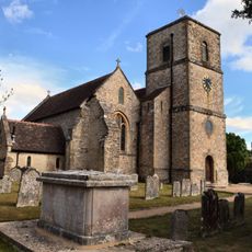
The Parish Church of St Mary the Virgin
101 m
31 and 33, Church Street
24 m
Storrington Library
279 m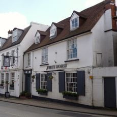
The Old Market Rooms The White Horse Hotel
151 m
Storrington War Memorial
126 m
Mulberry House
201 m
Ladye Place
313 m
10-14, Brewers Yard
245 m
Animal Fare The Old Forge
79 m
1 and 3, School Hill
298 m
18 20 And 22, High Street
196 m
Stone House
291 m
Abbey Convent
188 m
The Palace
41 m
The Horsecroft
161 m
14 16 And 18, West Street
160 m
Emmas Market And Old Rosemary
71 m
9, High Street
212 m
16 And 17, Brewers Yard
230 m
11, West Street
124 m
4-9, Brewers Yard
260 m
Gateway At The North West Corner Of The Kitchen Garden Wall Of St Joseph's Dominican Convent At The Corner Of Brown's Lane And Church Street
28 m
Nifty Art Gallery
284 m
Little Boltons Louis Austin
106 m
7 And 9, West Street
132 m
2 And 4, East Brook
304 m
2, School Hill
305 mReviews
Visited this place? Tap the stars to rate it and share your experience / photos with the community! Try now! You can cancel it anytime.
Discover hidden gems everywhere you go!
From secret cafés to breathtaking viewpoints, skip the crowded tourist spots and find places that match your style. Our app makes it easy with voice search, smart filtering, route optimization, and insider tips from travelers worldwide. Download now for the complete mobile experience.

A unique approach to discovering new places❞
— Le Figaro
All the places worth exploring❞
— France Info
A tailor-made excursion in just a few clicks❞
— 20 Minutes