Sunnyside Farm, agricultural structure in Padworth, West Berkshire, Berkshire, UK
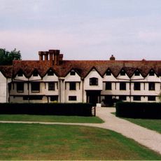
Ufton Court
1.7 km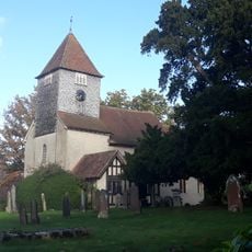
Church of St John the Baptist
1.8 km
Manse (Now 2 Houses) Attached To The Countess Of Huntingdon's Chapel
1.3 km
Round barrow cemetery at Holden's Firs
1.7 km
Countess Of Huntingdon's Chapel
1.3 km
The Red Lion Public House
1.7 km
Mortimer West End War Memorial
1.5 km
Grim's Bank: section extending 420yds (400m) in Old Park and Raven Hill, Ufton Park
1.1 km
Grim's Bank: section extending 880yds (795m) in Old Warren
1.5 km
Grim's Bank: section extending 300yds (275m) in Church Plantation
1.8 km
Granary (2) South-West Of West End Farmhouse
1.5 km
Barn (2) To North East Of West End Farmhouse
1.5 km
Grim's Bank: section extending 560yds (510m) in Pennsylvania Wood, Ufton Park
1.4 km
Hatch Farmhouse
835 m
Grim's Bank: section extending 240yds (220m) E of Padworth Gully
1 km
Grim's Bank: section extending SW 900yds (825m) from New Plantation, Ufton Park, to a point 250yds (230m) SE of Rectory
853 m
West End Farmhouse
1.5 km
Outbuildings, Attached To Granary (1)
1.5 km
Barn Approximately 30 Metres To North East Of Ufton Court
1.7 km
Seven fishponds at Ufton Court
1.8 km
Granary (1) To North Of Barn (2)
1.5 km
Bowl barrow: part of a barrow cemetery in Holden's Firs
1.7 km
Pump Approximately 20 Metres To South West Of Ufton Court
1.7 km
Round barrow at Ufton Nervet 190m south-west of Island Farm Cottage
1.8 km
Yew Tree Cottage
391 m
Walled Garden And Terrace Approximately 20 Metres To South West Of Ufton Court
1.7 km
Barn (1) To West Of West End Farmhouse
1.5 km
Bowl barrow north of Holden's Firs: part of the Holden's Firs barrow cemetery
1.5 kmReviews
Visited this place? Tap the stars to rate it and share your experience / photos with the community! Try now! You can cancel it anytime.
Discover hidden gems everywhere you go!
From secret cafés to breathtaking viewpoints, skip the crowded tourist spots and find places that match your style. Our app makes it easy with voice search, smart filtering, route optimization, and insider tips from travelers worldwide. Download now for the complete mobile experience.

A unique approach to discovering new places❞
— Le Figaro
All the places worth exploring❞
— France Info
A tailor-made excursion in just a few clicks❞
— 20 Minutes