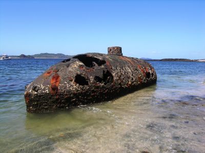
Sub Marine Explorer, 19th century submarine near San Jose Island, Panama
The Sub Marine Explorer is a submarine vessel from the 19th century located near San Jose Island, Panama, measuring about 39 feet in length. It features a pressurized working chamber connected to water ballast tanks and air compartments that allowed it to operate underwater.
The vessel was constructed between 1863 and 1866 in Brooklyn, New York, by Julius H. Kroehl and Ariel Patterson for the Pacific Pearl Company. It represented an early example of submersible technology developed for commercial pearl harvesting operations.
The vessel remained misidentified by local residents as a World War II submarine until archaeologist James P. Delgado uncovered its true identity in 2001.
The wreck rests in relatively shallow waters and remains accessible to divers under suitable conditions. Visitors planning to see it should check local conditions and access options before traveling to the area.
The vessel conducted pearl harvesting at depths of about 103 feet, with crews enduring four-hour dives under dangerous decompression conditions. Archaeologist James P. Delgado uncovered its true identity in 2001 after local residents had long misidentified it.
GPS coordinates: 8.28158,-78.84589
Latest update: December 21, 2025 17:22
Playa Otoñal
13.3 kmPlaya Grande (lapyahan sa Panama, Provincia de Panamá, lat 8,48, long -79,07)
33.1 kmPlaya Grande (lapyahan sa Panama, Provincia de Panamá, lat 8,23, long -78,92)
9.9 kmPlaya Grillo
10.6 kmPlaya de Santana
22.2 kmPlaya de Cinique
4 kmPlaya de Chiquero
2.2 kmPlaya de San Juan
3.7 kmPlaya de Río Sucio
13.7 kmPlaya de Viveros
27.3 kmPlaya de Punta Coco
8.8 kmPlaya María Grande
20.2 kmPlaya Ensenada
27.9 kmPlaya de San Agustín (lapyahan sa Panama)
22.7 kmPlaya Grande (lapyahan sa Panama, Provincia de Panamá, lat 8,48, long -78,99)
26.7 kmPlaya Bongo
19 kmPlaya Martín Pérez
16.8 kmPlaya Prieta
5.2 kmPlaya Grande (lapyahan sa Panama, Provincia de Panamá, lat 8,52, long -79,05)
34.5 kmPlaya Blanca (lapyahan sa Panama, Provincia de Panamá, lat 8,48, long -79,05)
31.8 kmPlaya Limón (lapyahan sa Panama)
8.1 kmPlaya de La Legua
14.5 kmPlaya de Esmeralda
8.4 kmPlaya de Cacique
6.5 kmPlaya de Cocal
32.2 kmPlaya Grande (lapyahan sa Panama, Provincia de Panamá, lat 8,25, long -79,10)
28.4 kmPlaya Mafafita
8.1 kmPlaya Brazo
8.4 kmVisited this place? Tap the stars to rate it and share your experience / photos with the community! Try now! You can cancel it anytime.
Discover hidden gems everywhere you go!
From secret cafés to breathtaking viewpoints, skip the crowded tourist spots and find places that match your style. Our app makes it easy with voice search, smart filtering, route optimization, and insider tips from travelers worldwide. Download now for the complete mobile experience.
A unique approach to discovering new places❞
— Le Figaro
All the places worth exploring❞
— France Info
A tailor-made excursion in just a few clicks❞
— 20 Minutes