Utrecht Golf Course
Location: eMadlangeni Local Municipality
GPS coordinates: -27.64075,30.33785
Latest update: October 7, 2024 20:49
Ncandu Falls
53.9 km
Fort Amiel Museum
42.7 km
Zaaihoek Dam
35.5 km
Majubaberg
51.1 km
Verdrukdam
52.9 km
Tom Worthington Dam
52.6 km
Madlangampisiberg
50.2 km
Rensburg
31 km
KwaMqongwane
51.3 km
Pulpit Rock
45.3 km
Ruins, scenic viewpoint
46.8 km
Vryheid Boating Club
41.4 km
Holkrans Memorial
44.5 km
Battle of Scheepersnek
40 km
Monument
45.4 km
ABW - North Gun Point
45.9 km
ABW - Signal Hill
46.1 km
Scenic viewpoint
46.6 km
Newcastle Magistrates Court
42 km
ABW - South Gun Point
47.4 km
Klipfontein Bird Sanctuary
47.4 km
Vryheid Golf Course
47.7 km
Waterfall
39.9 km
Old Road Bridge
38.2 km
19d steam locomotive
37.2 km
The British Cemetery at Kambula Battlefield
33 km
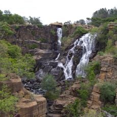
Waterfall
19.2 km
Waterfall
53.2 kmReviews
Visited this place? Tap the stars to rate it and share your experience / photos with the community! Try now! You can cancel it anytime.
Discover hidden gems everywhere you go!
From secret cafés to breathtaking viewpoints, skip the crowded tourist spots and find places that match your style. Our app makes it easy with voice search, smart filtering, route optimization, and insider tips from travelers worldwide. Download now for the complete mobile experience.

A unique approach to discovering new places❞
— Le Figaro
All the places worth exploring❞
— France Info
A tailor-made excursion in just a few clicks❞
— 20 Minutes