Victoria West Golf Club
Location: Ubuntu Local Municipality
GPS coordinates: -31.40142,23.13538
Latest update: December 4, 2025 06:15
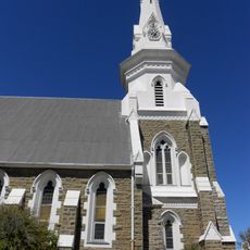
Beaufort West Reformed Church
117.8 km
Toorberg
120.5 km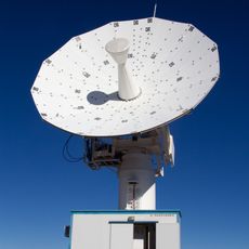
C-BASS South
120 km
Beaufort West Dam
116.9 km
Bobbejaankrans
83.3 km
Elandshoek
42.7 km
Bobbejaankrans
54.6 km
Bobbejaankrans
52.2 km
Aspelingdam
34.8 km
Bulbaken
93.1 km
Heuningneskrans
45.3 km
Die Krans
117.6 km
Rooikrans
100.5 km
Grootkrans
69.6 km
Papdam
120.4 km
Modderpoort Reservoir
112 km
Carnarvon Museum
107.2 km
Carnarvon Golf Club
108 km
Corbelled House
107.2 km
Bird Hide
119.6 km
Riverine Rabbit Thinking Path
75 km
Tauranga - Pitcairn
10.3 km
Scenic viewpoint
115.8 km
Scenic viewpoint
84.2 km
Memorial
76.9 km
Cannon
118.1 km
Memorial, commemorative plaque
118.2 km
Memorial, commemorative plaque
118.2 kmReviews
Visited this place? Tap the stars to rate it and share your experience / photos with the community! Try now! You can cancel it anytime.
Discover hidden gems everywhere you go!
From secret cafés to breathtaking viewpoints, skip the crowded tourist spots and find places that match your style. Our app makes it easy with voice search, smart filtering, route optimization, and insider tips from travelers worldwide. Download now for the complete mobile experience.

A unique approach to discovering new places❞
— Le Figaro
All the places worth exploring❞
— France Info
A tailor-made excursion in just a few clicks❞
— 20 Minutes