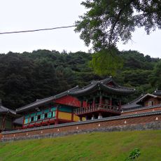
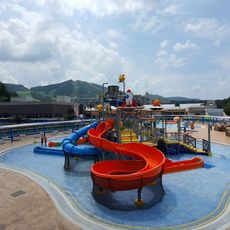
골프연습장

Log in to your account

AroundUs is a community-driven map of interesting places, built by curious explorers like you. It grows with every review, story, and photo you share.
Connect to save your favorite spots, contribute locations, and create personalized routes.
By continuing, you accept our Terms and Conditions and our Privacy Policy

골프연습장

Location: 안흥면

GPS coordinates: 37.45969,128.14028

Latest update: November 13, 2025 15:54

Around this place
Show the full map
Guryongsa
South Korea

Guryongsa

10.4 km
웰리힐리파크 워터플래닛
South Korea

웰리힐리파크 워터플래닛

10.6 km
Suri-bong (tumoy sa bukid sa Habagatang Korea, Gangwon-do, lat 37,46, long 128,29)
South Korea

Suri-bong (tumoy sa bukid sa Habagatang Korea, Gangwon-do, lat 37,46, long 128,29)

13.6 km
Kuksa-bong (tumoy sa bukid sa Habagatang Korea, Gangwon-do)
South Korea

Kuksa-bong (tumoy sa bukid sa Habagatang Korea, Gangwon-do)

10.5 km
Kuri-bong
South Korea

Kuri-bong

12 km
Chu-bong (tumoy sa bukid sa Habagatang Korea)
South Korea

Chu-bong (tumoy sa bukid sa Habagatang Korea)

8 km
Chaju-bong (tumoy sa bukid sa Habagatang Korea)
South Korea

Chaju-bong (tumoy sa bukid sa Habagatang Korea)

13.6 km
Seryŏm-p'okp'o
South Korea

Seryŏm-p'okp'o

11.1 km
Sam-bong (tumoy sa bukid sa Habagatang Korea, Gangwon-do, lat 37,37, long 128,04)
South Korea

Sam-bong (tumoy sa bukid sa Habagatang Korea, Gangwon-do, lat 37,37, long 128,04)

13.4 km
P'yottae-bong
South Korea

P'yottae-bong

8.4 km
Suri-bong (tumoy sa bukid sa Habagatang Korea, Gangwon-do, lat 37,48, long 128,24)
South Korea

Suri-bong (tumoy sa bukid sa Habagatang Korea, Gangwon-do, lat 37,48, long 128,24)

9.4 km
Kuryong-p'okp'o (busay sa Habagatang Korea, lat 37,40, long 128,05)
South Korea

Kuryong-p'okp'o (busay sa Habagatang Korea, lat 37,40, long 128,05)

10.5 km
Sakkap-pong (tumoy sa bukid sa Habagatang Korea, Gangwon-do, lat 37,39, long 128,21)
South Korea

Sakkap-pong (tumoy sa bukid sa Habagatang Korea, Gangwon-do, lat 37,39, long 128,21)

9.9 km
Yongma-bong
South Korea

Yongma-bong

13.5 km
Sam-bong (tumoy sa bukid sa Habagatang Korea, Gangwon-do, lat 37,34, long 128,11)
South Korea

Sam-bong (tumoy sa bukid sa Habagatang Korea, Gangwon-do, lat 37,34, long 128,11)

13.4 km
Sottae-bong
South Korea

Sottae-bong

11.7 km
파크밸리GC
South Korea

파크밸리GC

13.7 km
웰리힐리CC
South Korea

웰리힐리CC

8.8 km
전통마을 숲
South Korea

전통마을 숲

6.5 km
Alps Daeyoung Country Club
South Korea

Alps Daeyoung Country Club

6 km
미술관 자작나무숲
South Korea

미술관 자작나무숲

8.8 km
호수길전망대
South Korea

호수길전망대

12.4 km
Scenic viewpoint
South Korea

Scenic viewpoint

12.9 km
쥐너미재전망대
South Korea

쥐너미재전망대

13.3 km
말등바위전망대
South Korea

말등바위전망대

12 km
Memorial
South Korea

Memorial

5.8 km
숯가마터
South Korea

숯가마터

12.5 km
세렴폭포
South Korea

세렴폭포

11.1 km
Show the full map

Reviews

Visited this place? Tap the stars to rate it and share your experience / photos with the community! Try now! You can cancel it anytime.

« 골프연습장 » is provided by Around Us (aroundus.com). Images and texts are derived from Wikimedia project under a Creative Commons license. You are allowed to copy, distribute, and modify copies of this page, under the conditions set by the license, as long as this note is clearly visible.

Discover hidden gems everywhere you go!

From secret cafés to breathtaking viewpoints, skip the crowded tourist spots and find places that match your style. Our app makes it easy with voice search, smart filtering, route optimization, and insider tips from travelers worldwide. Download now for the complete mobile experience.

Around Us App Screenshot

A unique approach to discovering new places

Le Figaro

All the places worth exploring

France Info

A tailor-made excursion in just a few clicks

20 Minutes