Driving Range
Location: Town of Carstairs
GPS coordinates: 51.57720,-114.09459
Latest update: November 19, 2025 04:25

Knox Presbyterian Church
1.6 km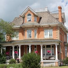
Hiebert Residence
10.2 km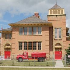
Red Brick School
10 km
Pokotilo Block
23.9 km
Former Bank of Montreal
23.9 km
Airdrie Erratic
31.3 km
Former Canadian Bank of Commerce
23.8 km
Kemp Block
23.9 km
Maybank Drug Store
23.9 km
Brown Residence
24 km
5206-50 Avenue
23.7 km
J.V. Berscht Block
9.7 km
W.M. Craig House
23.8 km
Dr. Hartman Residence
23.9 km
Carstairs Community Golf Course
494 m
Didsbury Golf Club
10.1 km
Collicutt Siding Golf Club
18.9 km
Olds Golf Course
25.6 km
Apple Creek Golf Course
25.9 km
Tooth of the Dogpound Creek Golf Course
20.1 km
Olds Regional Exhibition and Rodeo Grounds
23.5 km
CLC Fine Arts and Multimedia Centre
23.2 km
BMO Amphitheater
23.8 km
Different Strokes
23.9 km
Carstairs Heritage Centre
1.6 km
Valarosa Wetlands lookout 1
10.8 km
Valarosa Wetlands lookout 2
10.8 km
Scenic viewpoint
2.8 kmReviews
Visited this place? Tap the stars to rate it and share your experience / photos with the community! Try now! You can cancel it anytime.
Discover hidden gems everywhere you go!
From secret cafés to breathtaking viewpoints, skip the crowded tourist spots and find places that match your style. Our app makes it easy with voice search, smart filtering, route optimization, and insider tips from travelers worldwide. Download now for the complete mobile experience.

A unique approach to discovering new places❞
— Le Figaro
All the places worth exploring❞
— France Info
A tailor-made excursion in just a few clicks❞
— 20 Minutes