Parque Municipal
Location: San Miguel Chicaj
GPS coordinates: 15.09443,-90.39522
Latest update: November 18, 2025 11:02
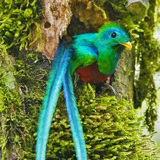
Biotopo del Quetzal
20.5 km
Calvario
31.9 km
Casa del Quetzal y la Marimba, Museo
8.6 km
Salama Sign
7.8 km
Bust, Work of art
23.4 km
Parque Central
23.5 km
Mercado
23.5 km
Plaza central
37.1 km
Twin pyramids
38 km
Ball court
37.8 km
Pyramid A1
37.8 km
Tunnel entrance
37.8 km
Teatro Municipal
10.4 km
Barbacoa y Playa
37.4 km
Parque Central
24.2 km
Work of art
22.9 km
El Chupadero
22.9 km
Scenic viewpoint
22.8 km
Scenic viewpoint
23.2 km
Scenic viewpoint, public toilet
23.2 km
Waterfall
22.8 km
Waterfall
23 km
Waterfall
23 km
Rubel Po
24.8 km
Waterfall
23.9 km
Waterfall
23.2 km
Catarata Salto de Chilascó
29.5 km
Waterfall
23.1 kmReviews
Visited this place? Tap the stars to rate it and share your experience / photos with the community! Try now! You can cancel it anytime.
Discover hidden gems everywhere you go!
From secret cafés to breathtaking viewpoints, skip the crowded tourist spots and find places that match your style. Our app makes it easy with voice search, smart filtering, route optimization, and insider tips from travelers worldwide. Download now for the complete mobile experience.

A unique approach to discovering new places❞
— Le Figaro
All the places worth exploring❞
— France Info
A tailor-made excursion in just a few clicks❞
— 20 Minutes