مخيم السمارة
Location: Tindouf ⵜⵉⵏⴷⵓⴼ تندوف
GPS coordinates: 27.48997,-7.82699
Latest update: November 12, 2025 14:52
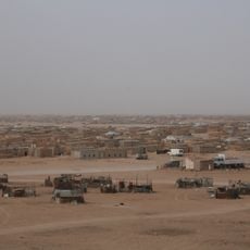
Sahrawi refugee camps
29.4 km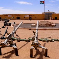
People's Liberation Army Museum
35.9 km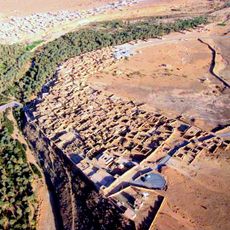
Ksar of Assa
200.5 km
ترخيس
122 km
Work of art
158.8 km
Dakhla
119.5 km
مجهر لربط
169.2 km
حجرت 169 كلم
161.3 km
شانطي لكماين تل البكريات
113.9 km
Gravures Rupestres
198 km
Gravures Rupestres
206.7 km
Gravures Supestres Oum Laalegue
209.4 km
Elmakraze
208.5 km
RTAA 003
194.2 km
Café Nahda
34.6 km
مقيدر ألطرفاية
134.1 km
Dakhla
119.5 km
Scenic viewpoint
69.4 km
Province d'Es-Semara
369 m
Scenic viewpoint
199.1 km
Blue rocks
203.8 km
Scenic viewpoint
200.6 km
Nisanian Pentagram
209.6 km
قاعدة الشهيد هداد
40.1 km
Tamzar
216.8 km
Oued Tam
213.1 km
Petroglyphs of Akka
208.1 km
Waterfall
217.2 kmReviews
Visited this place? Tap the stars to rate it and share your experience / photos with the community! Try now! You can cancel it anytime.
Discover hidden gems everywhere you go!
From secret cafés to breathtaking viewpoints, skip the crowded tourist spots and find places that match your style. Our app makes it easy with voice search, smart filtering, route optimization, and insider tips from travelers worldwide. Download now for the complete mobile experience.

A unique approach to discovering new places❞
— Le Figaro
All the places worth exploring❞
— France Info
A tailor-made excursion in just a few clicks❞
— 20 Minutes