
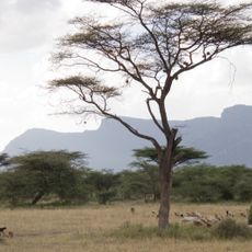
Lchoro lolosowan Water Point
Location: Waso ward
Email: sera@nrt-kenya.org
GPS coordinates: 1.11956,37.82066
Latest update: November 7, 2025 00:12
Shaba National Reserve
52.3 km
Segererua Plateau
50.9 km
Losai Peak
55.1 km
Chanlers Falls
47.4 km
Network area
36.1 km
Mt Kamanga
41.6 km
Kisima Hamsini (50 Wells)
12.2 km
Lgoita Rocks
51.5 km
Buffalo Springs Swimming Hole
60.2 km
Lontopi Water hole
7.1 km
Kamanga junction
54.1 km
To kamanga
37.1 km
Kwa network
43.5 km
To Olkanjao
52.1 km
Gotu Falls
47.6 km
Gong Rock
12.3 km
Santuario degli Elefanti Reteti
40.1 km
St George Statue
52.1 km
Lgoita Rocks Sundowner Spot
51.2 km
Lowa Mara Viewpoint
62.3 km
Shaba Main Viewpoint
52.5 km
River Viewpoint
48.5 km
River Viewpoint
50.6 km
Scenic viewpoint, mountain, summit, hill
51.2 km
Sunset Viewpoint
52.3 km
Scenic viewpoint
53.6 km
River Viewpoint JF
49.9 km
Sunrise viewpoint
53.1 kmReviews
Visited this place? Tap the stars to rate it and share your experience / photos with the community! Try now! You can cancel it anytime.
Discover hidden gems everywhere you go!
From secret cafés to breathtaking viewpoints, skip the crowded tourist spots and find places that match your style. Our app makes it easy with voice search, smart filtering, route optimization, and insider tips from travelers worldwide. Download now for the complete mobile experience.

A unique approach to discovering new places❞
— Le Figaro
All the places worth exploring❞
— France Info
A tailor-made excursion in just a few clicks❞
— 20 Minutes