Rice Fields
Location: ខេត្តបន្ទាយមានជ័យ
GPS coordinates: 13.61496,103.25974
Latest update: November 4, 2025 21:12

Ang Trapaing Thmor
28.6 km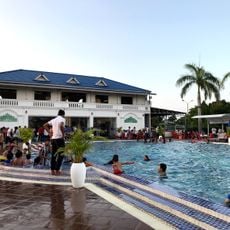
Boeng Chhouk Swimming Pool (Water Park)
27.8 km
Monument
24.8 km
Wayside shrine
10.5 km
HELICOPTER LANDING dBB2 SVAY CHEAK
38.2 km
Floating village breeding crocodiles
39.8 km
MongKul Borei 1 ADP of ACPC
43.4 km
Rice Fields
26.8 km
Old Lookout Tower
32.1 km
Ta Vong Pagode
17.9 km
Grandpa Lak's corpse
30.6 km
Phum Svay
36.1 km
Rock with a view
32 km
Phum Prey Chas floating village
32.5 km
MongKul Borei 2 ADP of ACPC
27.4 km
Phneat Koh Pong Sat
24.3 km
រង្វង់មូលថ្មគោល
43 km
Monument
17.4 km
Shapely Women Statue
31.1 km
Monument
31.7 km
Jayavarman The 7-th
31.3 km
Head Statue of Jayaraman 7th
27.3 km
Wayside shrine
10.5 km
Wayside shrine
10.6 km
French Colonial Bridge
15.9 km
Wayside shrine
10.5 km
Wayside shrine
10.5 km
Kasen Temple
42.8 kmReviews
Visited this place? Tap the stars to rate it and share your experience / photos with the community! Try now! You can cancel it anytime.
Discover hidden gems everywhere you go!
From secret cafés to breathtaking viewpoints, skip the crowded tourist spots and find places that match your style. Our app makes it easy with voice search, smart filtering, route optimization, and insider tips from travelers worldwide. Download now for the complete mobile experience.

A unique approach to discovering new places❞
— Le Figaro
All the places worth exploring❞
— France Info
A tailor-made excursion in just a few clicks❞
— 20 Minutes