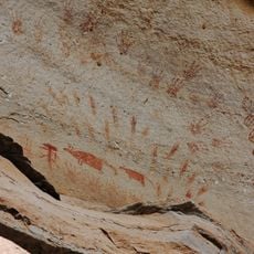
Had Khan Chao
Location: จังหวัดอุบลราชธานี
GPS coordinates: 15.56716,105.62413
Latest update: November 17, 2025 20:28
Pha Taem National Park
21.9 km
Phou Xieng Thong National Protected Area
10.4 km
Nam Tok Soi Sawan
13.1 km
Twin Rock Pillar
5.9 km
ผาชะนะได
6 km
Mushroom Rock
21.6 km
Pha Taem National Park
23.1 km
Sao Chaliang
22.3 km
Saeng Chan Waterfall
6.8 km
The 4th paintings group
21.6 km
Wild flowers fields
13.2 km
The 1st paintings group
22.5 km
The 2nd paintings group
22.2 km
Group 3: The painting at Pha Monnoi
21.8 km
Kaeng Pi Sa Mai Rocks on the Mekong River
23.8 km
Pha taem national park
19.7 km
Khua Nang Ni Waterfall
21.7 km
ผาชะนะได
6 km
ผาหมอน
21.5 km
น้ำตกสร้อยสวรรค์
12.9 km
Pha Moei
15.9 km
Pha Chek
15 km
ลานหินแตก
22.4 km
Tham Nang Lee Cave
22.6 km
น้ำตกสร้อยสวรรค์
12.9 km
Huay Na Mueang Yai Waterfall
4.9 km
น้ำตกห้วยพอก
6.9 km
น้ำตกกวงโตน
8.1 kmReviews
Visited this place? Tap the stars to rate it and share your experience / photos with the community! Try now! You can cancel it anytime.
Discover hidden gems everywhere you go!
From secret cafés to breathtaking viewpoints, skip the crowded tourist spots and find places that match your style. Our app makes it easy with voice search, smart filtering, route optimization, and insider tips from travelers worldwide. Download now for the complete mobile experience.

A unique approach to discovering new places❞
— Le Figaro
All the places worth exploring❞
— France Info
A tailor-made excursion in just a few clicks❞
— 20 Minutes